You are here: Home > Network List > TA - USArray Transportable Network (new EarthScope stations) Stations List
> Station E18K Tukpahlearik Creek, AK, USA > Earthquake Result Viewer
E18K Tukpahlearik Creek, AK, USA - Earthquake Result Viewer
| Earthquake location: |
Fiji Islands Region |
| Earthquake latitude/longitude: |
-18.0/-178.9 |
| Earthquake time(UTC): |
2017/08/19 (231) 02:00:52 GMT |
| Earthquake Depth: |
539 km |
| Earthquake Magnitude: |
6.4 Mww |
| Earthquake Catalog/Contributor: |
NEIC PDE/us |
|
| Network: |
TA USArray Transportable Network (new EarthScope stations) |
| Station: |
E18K Tukpahlearik Creek, AK, USA |
| Lat/Lon: |
67.42 N/160.60 W |
| Elevation: |
297 m |
|
| Distance: |
86.2 deg |
| Az: |
6.96 deg |
| Baz: |
197.38 deg |
| Ray Param: |
0.042701904 |
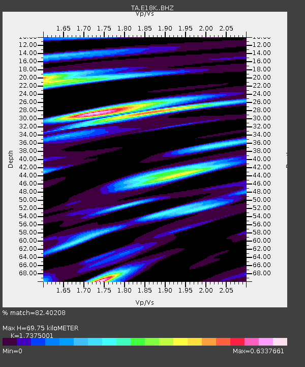
| Estimated Moho Depth: |
69.75 km |
| Estimated Crust Vp/Vs: |
1.74 |
| Assumed Crust Vp: |
6.276 km/s |
| Estimated Crust Vs: |
3.612 km/s |
| Estimated Crust Poisson's Ratio: |
0.25 |
|
| Radial Match: |
82.40208 % |
| Radial Bump: |
388 |
| Transverse Match: |
80.19382 % |
| Transverse Bump: |
400 |
| SOD ConfigId: |
13570011 |
| Insert Time: |
2019-04-28 15:18:48.787 +0000 |
| GWidth: |
2.5 |
| Max Bumps: |
400 |
| Tol: |
0.001 |
|
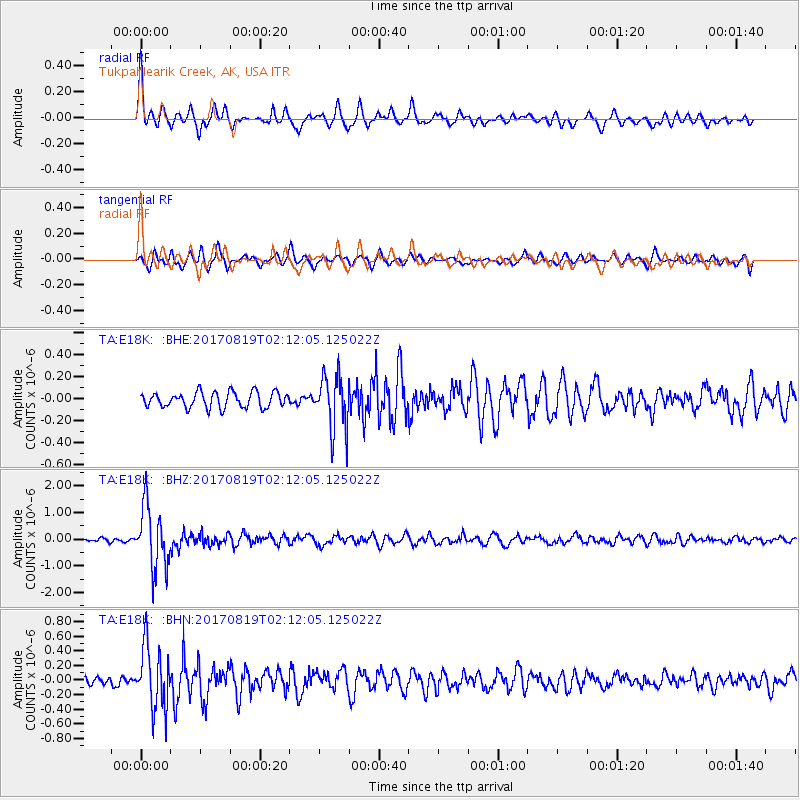
Signal To Noise
| Channel | StoN | STA | LTA |
| TA:E18K: :BHZ:20170819T02:12:05.125022Z | 20.706257 | 1.1653764E-6 | 5.6281362E-8 |
| TA:E18K: :BHN:20170819T02:12:05.125022Z | 6.582004 | 4.2432646E-7 | 6.446767E-8 |
| TA:E18K: :BHE:20170819T02:12:05.125022Z | 3.4655752 | 2.4522387E-7 | 7.075994E-8 |
| Arrivals |
| Ps | 8.4 SECOND |
| PpPs | 30 SECOND |
| PsPs/PpSs | 38 SECOND |


