You are here: Home > Network List > TA - USArray Transportable Network (new EarthScope stations) Stations List
> Station G21K Allakaket, AK, USA > Earthquake Result Viewer
G21K Allakaket, AK, USA - Earthquake Result Viewer
| Earthquake location: |
Fiji Islands Region |
| Earthquake latitude/longitude: |
-18.0/-178.9 |
| Earthquake time(UTC): |
2017/08/19 (231) 02:00:52 GMT |
| Earthquake Depth: |
539 km |
| Earthquake Magnitude: |
6.4 Mww |
| Earthquake Catalog/Contributor: |
NEIC PDE/us |
|
| Network: |
TA USArray Transportable Network (new EarthScope stations) |
| Station: |
G21K Allakaket, AK, USA |
| Lat/Lon: |
66.52 N/153.51 W |
| Elevation: |
446 m |
|
| Distance: |
86.3 deg |
| Az: |
9.898 deg |
| Baz: |
204.097 deg |
| Ray Param: |
0.042602926 |
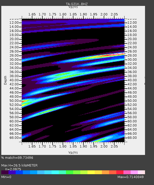
| Estimated Moho Depth: |
26.5 km |
| Estimated Crust Vp/Vs: |
2.10 |
| Assumed Crust Vp: |
6.455 km/s |
| Estimated Crust Vs: |
3.078 km/s |
| Estimated Crust Poisson's Ratio: |
0.35 |
|
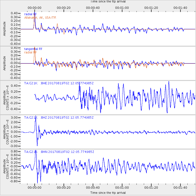
| Radial Match: |
89.73496 % |
| Radial Bump: |
343 |
| Transverse Match: |
78.38749 % |
| Transverse Bump: |
336 |
| SOD ConfigId: |
13570011 |
| Insert Time: |
2019-04-28 15:19:06.726 +0000 |
| GWidth: |
2.5 |
| Max Bumps: |
400 |
| Tol: |
0.001 |
|
Signal To Noise
| Channel | StoN | STA | LTA |
| TA:G21K: :BHZ:20170819T02:12:05.774985Z | 23.168848 | 1.4019208E-6 | 6.0508874E-8 |
| TA:G21K: :BHN:20170819T02:12:05.774985Z | 9.112949 | 4.406466E-7 | 4.8353893E-8 |
| TA:G21K: :BHE:20170819T02:12:05.774985Z | 3.6906817 | 2.161871E-7 | 5.8576468E-8 |
| Arrivals |
| Ps | 4.6 SECOND |
| PpPs | 12 SECOND |
| PsPs/PpSs | 17 SECOND |


