You are here: Home > Network List > TA - USArray Transportable Network (new EarthScope stations) Stations List
> Station K17K Iditarod, AK, USA > Earthquake Result Viewer
K17K Iditarod, AK, USA - Earthquake Result Viewer
| Earthquake location: |
Fiji Islands Region |
| Earthquake latitude/longitude: |
-18.0/-178.9 |
| Earthquake time(UTC): |
2017/08/19 (231) 02:00:52 GMT |
| Earthquake Depth: |
539 km |
| Earthquake Magnitude: |
6.4 Mww |
| Earthquake Catalog/Contributor: |
NEIC PDE/us |
|
| Network: |
TA USArray Transportable Network (new EarthScope stations) |
| Station: |
K17K Iditarod, AK, USA |
| Lat/Lon: |
62.72 N/158.30 W |
| Elevation: |
339 m |
|
| Distance: |
82.0 deg |
| Az: |
9.4 deg |
| Baz: |
199.716 deg |
| Ray Param: |
0.04559297 |
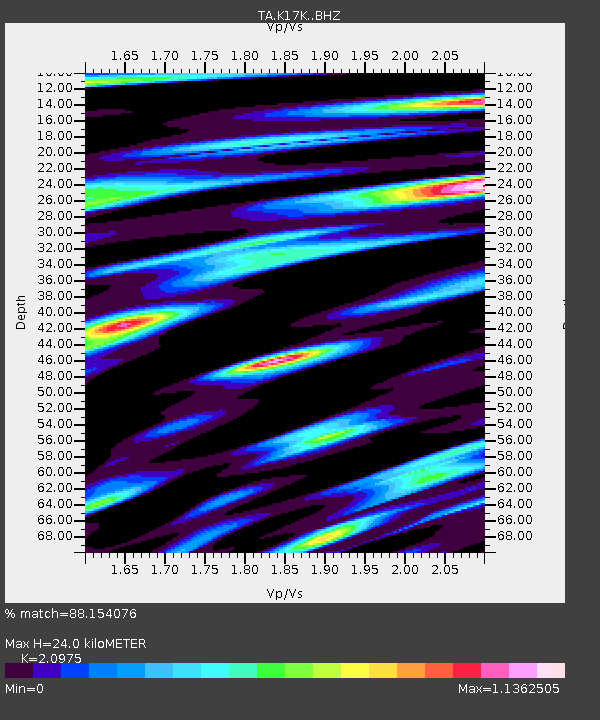
| Estimated Moho Depth: |
24.0 km |
| Estimated Crust Vp/Vs: |
2.10 |
| Assumed Crust Vp: |
6.276 km/s |
| Estimated Crust Vs: |
2.992 km/s |
| Estimated Crust Poisson's Ratio: |
0.35 |
|
| Radial Match: |
88.154076 % |
| Radial Bump: |
400 |
| Transverse Match: |
81.01194 % |
| Transverse Bump: |
400 |
| SOD ConfigId: |
13570011 |
| Insert Time: |
2019-04-28 15:19:41.053 +0000 |
| GWidth: |
2.5 |
| Max Bumps: |
400 |
| Tol: |
0.001 |
|

Signal To Noise
| Channel | StoN | STA | LTA |
| TA:K17K: :BHZ:20170819T02:11:44.699973Z | 37.32055 | 2.9006085E-6 | 7.772148E-8 |
| TA:K17K: :BHN:20170819T02:11:44.699973Z | 10.788347 | 9.487572E-7 | 8.794277E-8 |
| TA:K17K: :BHE:20170819T02:11:44.699973Z | 4.5128107 | 4.667728E-7 | 1.0343284E-7 |
| Arrivals |
| Ps | 4.3 SECOND |
| PpPs | 12 SECOND |
| PsPs/PpSs | 16 SECOND |


