You are here: Home > Network List > TA - USArray Transportable Network (new EarthScope stations) Stations List
> Station L18K Granite Mountain, AK, USA > Earthquake Result Viewer
L18K Granite Mountain, AK, USA - Earthquake Result Viewer
| Earthquake location: |
Fiji Islands Region |
| Earthquake latitude/longitude: |
-18.0/-178.9 |
| Earthquake time(UTC): |
2017/08/19 (231) 02:00:52 GMT |
| Earthquake Depth: |
539 km |
| Earthquake Magnitude: |
6.4 Mww |
| Earthquake Catalog/Contributor: |
NEIC PDE/us |
|
| Network: |
TA USArray Transportable Network (new EarthScope stations) |
| Station: |
L18K Granite Mountain, AK, USA |
| Lat/Lon: |
62.22 N/156.69 W |
| Elevation: |
329 m |
|
| Distance: |
81.8 deg |
| Az: |
10.286 deg |
| Baz: |
201.269 deg |
| Ray Param: |
0.04572797 |
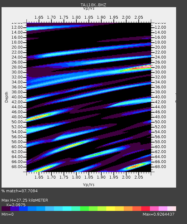
| Estimated Moho Depth: |
27.25 km |
| Estimated Crust Vp/Vs: |
2.10 |
| Assumed Crust Vp: |
6.182 km/s |
| Estimated Crust Vs: |
2.947 km/s |
| Estimated Crust Poisson's Ratio: |
0.35 |
|
| Radial Match: |
87.7094 % |
| Radial Bump: |
400 |
| Transverse Match: |
83.295746 % |
| Transverse Bump: |
400 |
| SOD ConfigId: |
13570011 |
| Insert Time: |
2019-04-28 15:19:49.442 +0000 |
| GWidth: |
2.5 |
| Max Bumps: |
400 |
| Tol: |
0.001 |
|

Signal To Noise
| Channel | StoN | STA | LTA |
| TA:L18K: :BHZ:20170819T02:11:43.649985Z | 40.08033 | 2.8491997E-6 | 7.1087236E-8 |
| TA:L18K: :BHN:20170819T02:11:43.649985Z | 10.352832 | 7.5708226E-7 | 7.3128035E-8 |
| TA:L18K: :BHE:20170819T02:11:43.649985Z | 9.191818 | 3.9283228E-7 | 4.2737167E-8 |
| Arrivals |
| Ps | 4.9 SECOND |
| PpPs | 13 SECOND |
| PsPs/PpSs | 18 SECOND |


