You are here: Home > Network List > TA - USArray Transportable Network (new EarthScope stations) Stations List
> Station O05C Quincy, CA, USA > Earthquake Result Viewer
O05C Quincy, CA, USA - Earthquake Result Viewer
| Earthquake location: |
Central Peru |
| Earthquake latitude/longitude: |
-14.9/-74.6 |
| Earthquake time(UTC): |
2005/05/03 (123) 19:11:39 GMT |
| Earthquake Depth: |
31 km |
| Earthquake Magnitude: |
5.6 MB, 5.4 MS, 5.9 MW, 5.9 MW |
| Earthquake Catalog/Contributor: |
WHDF/NEIC |
|
| Network: |
TA USArray Transportable Network (new EarthScope stations) |
| Station: |
O05C Quincy, CA, USA |
| Lat/Lon: |
39.96 N/120.92 W |
| Elevation: |
1032 m |
|
| Distance: |
69.5 deg |
| Az: |
323.626 deg |
| Baz: |
131.762 deg |
| Ray Param: |
0.055537492 |
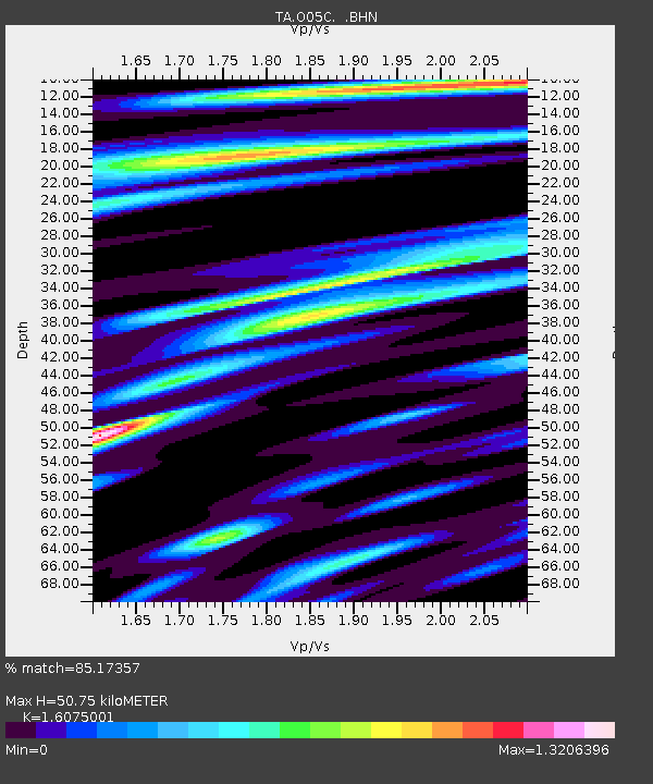
| Estimated Moho Depth: |
50.75 km |
| Estimated Crust Vp/Vs: |
1.61 |
| Assumed Crust Vp: |
6.597 km/s |
| Estimated Crust Vs: |
4.104 km/s |
| Estimated Crust Poisson's Ratio: |
0.18 |
|
| Radial Match: |
85.17357 % |
| Radial Bump: |
400 |
| Transverse Match: |
87.1317 % |
| Transverse Bump: |
400 |
| SOD ConfigId: |
142939 |
| Insert Time: |
2010-03-06 03:00:15.648 +0000 |
| GWidth: |
2.5 |
| Max Bumps: |
400 |
| Tol: |
0.001 |
|

Signal To Noise
| Channel | StoN | STA | LTA |
| TA:O05C: :BHN:20050503T19:22:14.475017Z | 2.5341537 | 1.4217885E-7 | 5.610506E-8 |
| TA:O05C: :BHE:20050503T19:22:14.475017Z | 1.6822242 | 2.0795012E-7 | 1.2361618E-7 |
| TA:O05C: :BHZ:20050503T19:22:14.475017Z | 6.755269 | 3.906307E-7 | 5.7826075E-8 |
| Arrivals |
| Ps | 4.9 SECOND |
| PpPs | 19 SECOND |
| PsPs/PpSs | 24 SECOND |


