You are here: Home > Network List > TA - USArray Transportable Network (new EarthScope stations) Stations List
> Station Q24A Divide, CO, USA > Earthquake Result Viewer
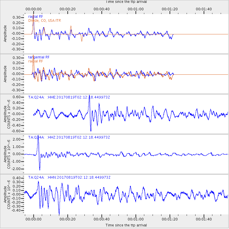
Q24A Divide, CO, USA - Earthquake Result Viewer
*The percent match for this event was below the threshold and hence no stack was calculated.
| Earthquake location: |
Fiji Islands Region |
| Earthquake latitude/longitude: |
-18.0/-178.9 |
| Earthquake time(UTC): |
2017/08/19 (231) 02:00:52 GMT |
| Earthquake Depth: |
539 km |
| Earthquake Magnitude: |
6.4 Mww |
| Earthquake Catalog/Contributor: |
NEIC PDE/us |
|
| Network: |
TA USArray Transportable Network (new EarthScope stations) |
| Station: |
Q24A Divide, CO, USA |
| Lat/Lon: |
38.96 N/105.15 W |
| Elevation: |
2775 m |
|
| Distance: |
89.1 deg |
| Az: |
48.449 deg |
| Baz: |
246.024 deg |
| Ray Param: |
$rayparam |
*The percent match for this event was below the threshold and hence was not used in the summary stack. |
|
| Radial Match: |
73.26709 % |
| Radial Bump: |
354 |
| Transverse Match: |
73.54405 % |
| Transverse Bump: |
308 |
| SOD ConfigId: |
13570011 |
| Insert Time: |
2019-04-28 15:20:37.237 +0000 |
| GWidth: |
2.5 |
| Max Bumps: |
400 |
| Tol: |
0.001 |
|
Signal To Noise
| Channel | StoN | STA | LTA |
| TA:Q24A: :HHZ:20170819T02:12:18.449973Z | 17.003468 | 1.01986E-6 | 5.9979534E-8 |
| TA:Q24A: :HHN:20170819T02:12:18.449973Z | 2.8873901 | 1.564244E-7 | 5.417502E-8 |
| TA:Q24A: :HHE:20170819T02:12:18.449973Z | 3.3704195 | 2.8126865E-7 | 8.345212E-8 |
| Arrivals |
| Ps | |
| PpPs | |
| PsPs/PpSs | |


