You are here: Home > Network List > TA - USArray Transportable Network (new EarthScope stations) Stations List
> Station R11B Troy Canyon, Currant, NV, USA > Earthquake Result Viewer
R11B Troy Canyon, Currant, NV, USA - Earthquake Result Viewer
| Earthquake location: |
Fiji Islands Region |
| Earthquake latitude/longitude: |
-18.0/-178.9 |
| Earthquake time(UTC): |
2017/08/19 (231) 02:00:52 GMT |
| Earthquake Depth: |
539 km |
| Earthquake Magnitude: |
6.4 Mww |
| Earthquake Catalog/Contributor: |
NEIC PDE/us |
|
| Network: |
TA USArray Transportable Network (new EarthScope stations) |
| Station: |
R11B Troy Canyon, Currant, NV, USA |
| Lat/Lon: |
38.35 N/115.59 W |
| Elevation: |
1767 m |
|
| Distance: |
81.5 deg |
| Az: |
45.231 deg |
| Baz: |
239.256 deg |
| Ray Param: |
0.04592611 |
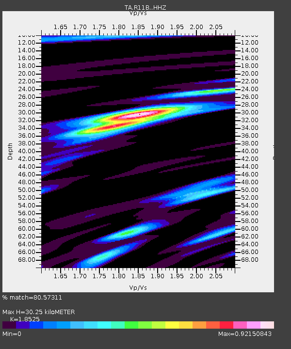
| Estimated Moho Depth: |
30.25 km |
| Estimated Crust Vp/Vs: |
1.85 |
| Assumed Crust Vp: |
6.276 km/s |
| Estimated Crust Vs: |
3.388 km/s |
| Estimated Crust Poisson's Ratio: |
0.29 |
|
| Radial Match: |
80.57311 % |
| Radial Bump: |
300 |
| Transverse Match: |
68.6138 % |
| Transverse Bump: |
400 |
| SOD ConfigId: |
13570011 |
| Insert Time: |
2019-04-28 15:20:39.246 +0000 |
| GWidth: |
2.5 |
| Max Bumps: |
400 |
| Tol: |
0.001 |
|

Signal To Noise
| Channel | StoN | STA | LTA |
| TA:R11B: :HHZ:20170819T02:11:42.139976Z | 30.064293 | 1.4692114E-6 | 4.8868984E-8 |
| TA:R11B: :HHN:20170819T02:11:42.139976Z | 12.185125 | 3.5743938E-7 | 2.9334073E-8 |
| TA:R11B: :HHE:20170819T02:11:42.139976Z | 8.598375 | 5.014889E-7 | 5.832368E-8 |
| Arrivals |
| Ps | 4.2 SECOND |
| PpPs | 13 SECOND |
| PsPs/PpSs | 18 SECOND |


