You are here: Home > Network List > TA - USArray Transportable Network (new EarthScope stations) Stations List
> Station O05C Quincy, CA, USA > Earthquake Result Viewer
O05C Quincy, CA, USA - Earthquake Result Viewer
| Earthquake location: |
New Ireland Region, P.N.G. |
| Earthquake latitude/longitude: |
-4.5/153.5 |
| Earthquake time(UTC): |
2005/09/09 (252) 07:26:43 GMT |
| Earthquake Depth: |
90 km |
| Earthquake Magnitude: |
6.3 MB, 7.7 MW, 7.5 MW |
| Earthquake Catalog/Contributor: |
WHDF/NEIC |
|
| Network: |
TA USArray Transportable Network (new EarthScope stations) |
| Station: |
O05C Quincy, CA, USA |
| Lat/Lon: |
39.96 N/120.92 W |
| Elevation: |
1032 m |
|
| Distance: |
89.5 deg |
| Az: |
50.028 deg |
| Baz: |
263.727 deg |
| Ray Param: |
0.041721683 |
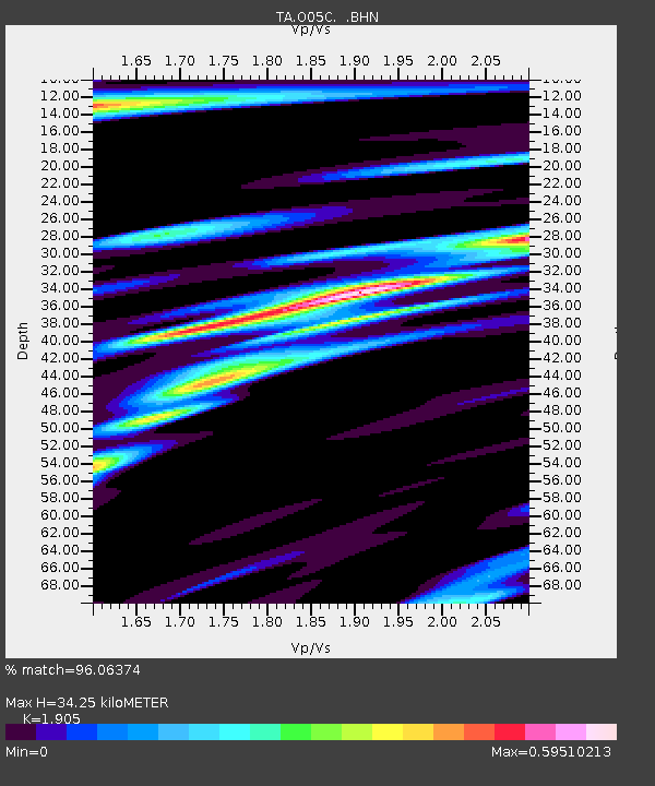
| Estimated Moho Depth: |
34.25 km |
| Estimated Crust Vp/Vs: |
1.90 |
| Assumed Crust Vp: |
6.597 km/s |
| Estimated Crust Vs: |
3.463 km/s |
| Estimated Crust Poisson's Ratio: |
0.31 |
|
| Radial Match: |
96.06374 % |
| Radial Bump: |
353 |
| Transverse Match: |
90.643425 % |
| Transverse Bump: |
400 |
| SOD ConfigId: |
2475 |
| Insert Time: |
2010-03-06 03:00:24.299 +0000 |
| GWidth: |
2.5 |
| Max Bumps: |
400 |
| Tol: |
0.001 |
|

Signal To Noise
| Channel | StoN | STA | LTA |
| TA:O05C: :BHN:20050909T07:38:59.75002Z | 1.2568623 | 1.5351702E-7 | 1.2214308E-7 |
| TA:O05C: :BHE:20050909T07:38:59.75002Z | 4.0095377 | 5.3622955E-7 | 1.337385E-7 |
| TA:O05C: :BHZ:20050909T07:38:59.75002Z | 8.09469 | 1.1577545E-6 | 1.430264E-7 |
| Arrivals |
| Ps | 4.8 SECOND |
| PpPs | 15 SECOND |
| PsPs/PpSs | 20 SECOND |


