You are here: Home > Network List > TA - USArray Transportable Network (new EarthScope stations) Stations List
> Station T25A Trinidad, CO, USA > Earthquake Result Viewer
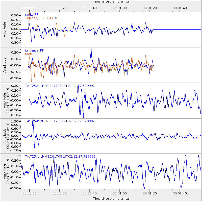
T25A Trinidad, CO, USA - Earthquake Result Viewer
*The percent match for this event was below the threshold and hence no stack was calculated.
| Earthquake location: |
Fiji Islands Region |
| Earthquake latitude/longitude: |
-18.0/-178.9 |
| Earthquake time(UTC): |
2017/08/19 (231) 02:00:52 GMT |
| Earthquake Depth: |
539 km |
| Earthquake Magnitude: |
6.4 Mww |
| Earthquake Catalog/Contributor: |
NEIC PDE/us |
|
| Network: |
TA USArray Transportable Network (new EarthScope stations) |
| Station: |
T25A Trinidad, CO, USA |
| Lat/Lon: |
37.14 N/104.41 W |
| Elevation: |
2017 m |
|
| Distance: |
88.9 deg |
| Az: |
50.352 deg |
| Baz: |
246.511 deg |
| Ray Param: |
$rayparam |
*The percent match for this event was below the threshold and hence was not used in the summary stack. |
|
| Radial Match: |
62.46245 % |
| Radial Bump: |
400 |
| Transverse Match: |
52.74503 % |
| Transverse Bump: |
361 |
| SOD ConfigId: |
13570011 |
| Insert Time: |
2019-04-28 15:20:49.689 +0000 |
| GWidth: |
2.5 |
| Max Bumps: |
400 |
| Tol: |
0.001 |
|
Signal To Noise
| Channel | StoN | STA | LTA |
| TA:T25A: :HHZ:20170819T02:12:17.52999Z | 7.1159153 | 5.472667E-7 | 7.6907426E-8 |
| TA:T25A: :HHN:20170819T02:12:17.52999Z | 0.96579254 | 9.143904E-8 | 9.467773E-8 |
| TA:T25A: :HHE:20170819T02:12:17.52999Z | 2.2643642 | 1.7160598E-7 | 7.57855E-8 |
| Arrivals |
| Ps | |
| PpPs | |
| PsPs/PpSs | |


