You are here: Home > Network List > TA - USArray Transportable Network (new EarthScope stations) Stations List
> Station O05C Quincy, CA, USA > Earthquake Result Viewer
O05C Quincy, CA, USA - Earthquake Result Viewer
| Earthquake location: |
Southeast Of Loyalty Islands |
| Earthquake latitude/longitude: |
-21.1/169.3 |
| Earthquake time(UTC): |
2007/09/27 (270) 19:57:44 GMT |
| Earthquake Depth: |
9.0 km |
| Earthquake Magnitude: |
6.2 MB, 6.3 MS, 6.1 MW, 6.1 MW |
| Earthquake Catalog/Contributor: |
WHDF/NEIC |
|
| Network: |
TA USArray Transportable Network (new EarthScope stations) |
| Station: |
O05C Quincy, CA, USA |
| Lat/Lon: |
39.96 N/120.92 W |
| Elevation: |
1032 m |
|
| Distance: |
88.9 deg |
| Az: |
46.174 deg |
| Baz: |
241.219 deg |
| Ray Param: |
0.042228304 |
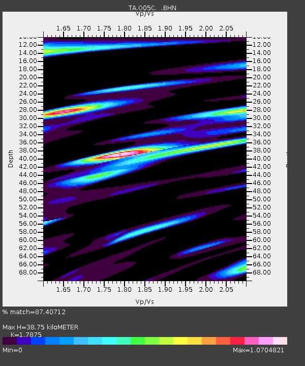
| Estimated Moho Depth: |
38.75 km |
| Estimated Crust Vp/Vs: |
1.79 |
| Assumed Crust Vp: |
6.597 km/s |
| Estimated Crust Vs: |
3.691 km/s |
| Estimated Crust Poisson's Ratio: |
0.27 |
|
| Radial Match: |
87.40712 % |
| Radial Bump: |
400 |
| Transverse Match: |
78.90215 % |
| Transverse Bump: |
400 |
| SOD ConfigId: |
2564 |
| Insert Time: |
2010-03-06 03:00:33.234 +0000 |
| GWidth: |
2.5 |
| Max Bumps: |
400 |
| Tol: |
0.001 |
|
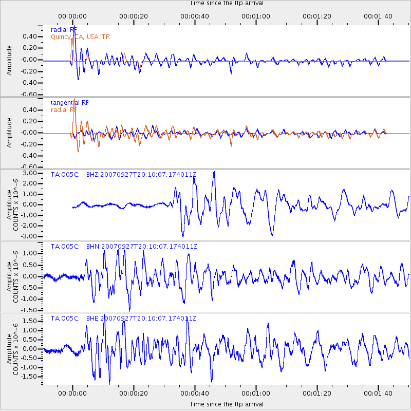
Signal To Noise
| Channel | StoN | STA | LTA |
| TA:O05C: :BHN:20070927T20:10:07.174011Z | 2.2645876 | 2.3838034E-7 | 1.0526434E-7 |
| TA:O05C: :BHE:20070927T20:10:07.174011Z | 3.3424785 | 4.062318E-7 | 1.215361E-7 |
| TA:O05C: :BHZ:20070927T20:10:07.174011Z | 4.4210553 | 6.2250655E-7 | 1.4080497E-7 |
| Arrivals |
| Ps | 4.7 SECOND |
| PpPs | 16 SECOND |
| PsPs/PpSs | 21 SECOND |


