You are here: Home > Network List > UW - Pacific Northwest Regional Seismic Network Stations List
> Station HOOD Mt Hood Meadows, OR CREST BB SMO > Earthquake Result Viewer
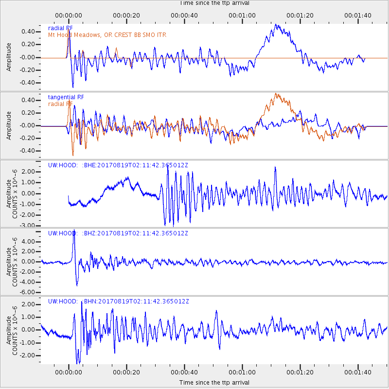
HOOD Mt Hood Meadows, OR CREST BB SMO - Earthquake Result Viewer
*The percent match for this event was below the threshold and hence no stack was calculated.
| Earthquake location: |
Fiji Islands Region |
| Earthquake latitude/longitude: |
-18.0/-178.9 |
| Earthquake time(UTC): |
2017/08/19 (231) 02:00:52 GMT |
| Earthquake Depth: |
539 km |
| Earthquake Magnitude: |
6.4 Mww |
| Earthquake Catalog/Contributor: |
NEIC PDE/us |
|
| Network: |
UW Pacific Northwest Regional Seismic Network |
| Station: |
HOOD Mt Hood Meadows, OR CREST BB SMO |
| Lat/Lon: |
45.32 N/121.65 W |
| Elevation: |
1520 m |
|
| Distance: |
81.6 deg |
| Az: |
36.833 deg |
| Baz: |
233.978 deg |
| Ray Param: |
$rayparam |
*The percent match for this event was below the threshold and hence was not used in the summary stack. |
|
| Radial Match: |
72.16085 % |
| Radial Bump: |
400 |
| Transverse Match: |
69.32326 % |
| Transverse Bump: |
400 |
| SOD ConfigId: |
13570011 |
| Insert Time: |
2019-04-28 15:21:41.206 +0000 |
| GWidth: |
2.5 |
| Max Bumps: |
400 |
| Tol: |
0.001 |
|
Signal To Noise
| Channel | StoN | STA | LTA |
| UW:HOOD: :BHZ:20170819T02:11:42.365012Z | 20.32055 | 2.458636E-6 | 1.2099258E-7 |
| UW:HOOD: :BHN:20170819T02:11:42.365012Z | 3.5657156 | 1.4634069E-6 | 4.1041042E-7 |
| UW:HOOD: :BHE:20170819T02:11:42.365012Z | 1.5053012 | 1.2528411E-6 | 8.32286E-7 |
| Arrivals |
| Ps | |
| PpPs | |
| PsPs/PpSs | |


