You are here: Home > Network List > TA - USArray Transportable Network (new EarthScope stations) Stations List
> Station O05C Quincy, CA, USA > Earthquake Result Viewer
O05C Quincy, CA, USA - Earthquake Result Viewer
| Earthquake location: |
Solomon Islands |
| Earthquake latitude/longitude: |
-9.8/159.5 |
| Earthquake time(UTC): |
2007/08/16 (228) 08:39:27 GMT |
| Earthquake Depth: |
10 km |
| Earthquake Magnitude: |
6.1 MB, 6.7 MS, 6.4 MW |
| Earthquake Catalog/Contributor: |
WHDF/NEIC |
|
| Network: |
TA USArray Transportable Network (new EarthScope stations) |
| Station: |
O05C Quincy, CA, USA |
| Lat/Lon: |
39.96 N/120.92 W |
| Elevation: |
1032 m |
|
| Distance: |
88.4 deg |
| Az: |
49.139 deg |
| Baz: |
255.871 deg |
| Ray Param: |
0.042619217 |
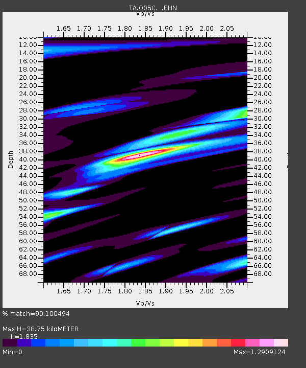
| Estimated Moho Depth: |
38.75 km |
| Estimated Crust Vp/Vs: |
1.84 |
| Assumed Crust Vp: |
6.597 km/s |
| Estimated Crust Vs: |
3.595 km/s |
| Estimated Crust Poisson's Ratio: |
0.29 |
|
| Radial Match: |
90.100494 % |
| Radial Bump: |
400 |
| Transverse Match: |
90.096 % |
| Transverse Bump: |
400 |
| SOD ConfigId: |
2564 |
| Insert Time: |
2010-03-06 03:00:40.865 +0000 |
| GWidth: |
2.5 |
| Max Bumps: |
400 |
| Tol: |
0.001 |
|
Signal To Noise
| Channel | StoN | STA | LTA |
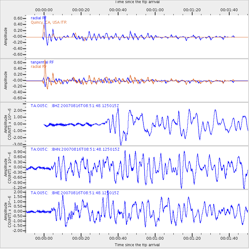
| TA:O05C: :BHN:20070816T08:51:48.125015Z | 0.97972363 | 5.0596828E-8 | 5.1643983E-8 |
| TA:O05C: :BHE:20070816T08:51:48.125015Z | 1.4296346 | 1.0816702E-7 | 7.566061E-8 |
| TA:O05C: :BHZ:20070816T08:51:48.125015Z | 3.2105172 | 3.3157892E-7 | 1.0327897E-7 |
| Arrivals |
| Ps | 5.0 SECOND |
| PpPs | 16 SECOND |
| PsPs/PpSs | 21 SECOND |


