You are here: Home > Network List > UW - Pacific Northwest Regional Seismic Network Stations List
> Station UMAT Pilot Rock, OR, USA > Earthquake Result Viewer
UMAT Pilot Rock, OR, USA - Earthquake Result Viewer

| Earthquake location: |
Fiji Islands Region |
| Earthquake latitude/longitude: |
-18.0/-178.9 |
| Earthquake time(UTC): |
2017/08/19 (231) 02:00:52 GMT |
| Earthquake Depth: |
539 km |
| Earthquake Magnitude: |
6.4 Mww |
| Earthquake Catalog/Contributor: |
NEIC PDE/us |
|
| Network: |
UW Pacific Northwest Regional Seismic Network |
| Station: |
UMAT Pilot Rock, OR, USA |
| Lat/Lon: |
45.29 N/118.96 W |
| Elevation: |
1318 m |
|
| Distance: |
83.1 deg |
| Az: |
37.958 deg |
| Baz: |
236.037 deg |
| Ray Param: |
0.04484743 |
| Estimated Moho Depth: |
36.0 km |
| Estimated Crust Vp/Vs: |
1.82 |
| Assumed Crust Vp: |
6.571 km/s |
| Estimated Crust Vs: |
3.615 km/s |
| Estimated Crust Poisson's Ratio: |
0.28 |
|
| Radial Match: |
94.24111 % |
| Radial Bump: |
311 |
| Transverse Match: |
79.27899 % |
| Transverse Bump: |
400 |
| SOD ConfigId: |
13570011 |
| Insert Time: |
2019-04-28 15:21:56.816 +0000 |
| GWidth: |
2.5 |
| Max Bumps: |
400 |
| Tol: |
0.001 |
|
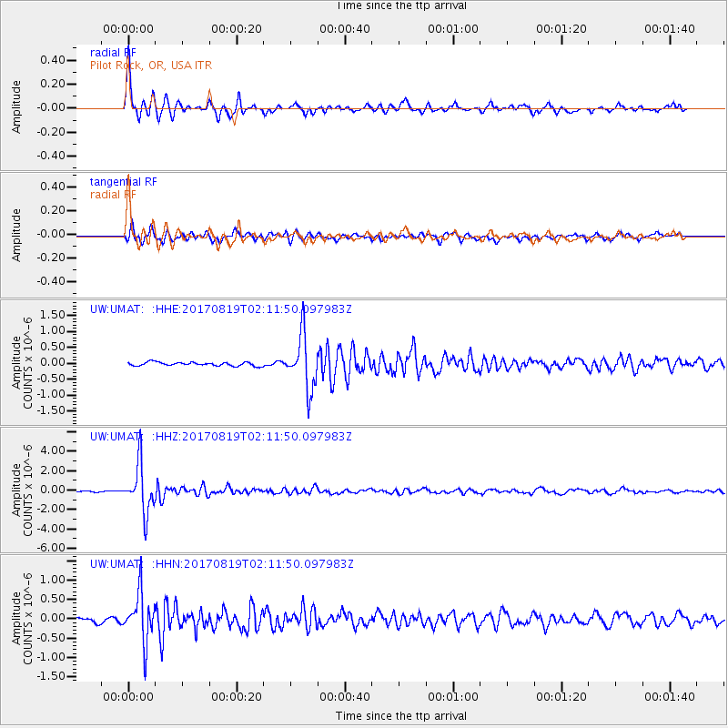
Signal To Noise
| Channel | StoN | STA | LTA |
| UW:UMAT: :HHZ:20170819T02:11:50.097983Z | 35.585224 | 2.505889E-6 | 7.041937E-8 |
| UW:UMAT: :HHN:20170819T02:11:50.097983Z | 10.002805 | 6.343852E-7 | 6.342072E-8 |
| UW:UMAT: :HHE:20170819T02:11:50.097983Z | 15.266409 | 8.5090454E-7 | 5.5737047E-8 |
| Arrivals |
| Ps | 4.6 SECOND |
| PpPs | 15 SECOND |
| PsPs/PpSs | 20 SECOND |


