You are here: Home > Network List > NM - Cooperative New Madrid Seismic Network Stations List
> Station CGM3 Cape Girardeau, MO > Earthquake Result Viewer
CGM3 Cape Girardeau, MO - Earthquake Result Viewer
| Earthquake location: |
Kamchatka Peninsula, Russia |
| Earthquake latitude/longitude: |
54.0/158.5 |
| Earthquake time(UTC): |
2016/01/30 (030) 03:25:10 GMT |
| Earthquake Depth: |
161 km |
| Earthquake Magnitude: |
7.2 MWW, 7.0 MI, 7.2 MWB |
| Earthquake Catalog/Contributor: |
NEIC PDE/NEIC COMCAT |
|
| Network: |
NM Cooperative New Madrid Seismic Network |
| Station: |
CGM3 Cape Girardeau, MO |
| Lat/Lon: |
37.30 N/89.66 W |
| Elevation: |
148 m |
|
| Distance: |
71.8 deg |
| Az: |
51.181 deg |
| Baz: |
324.781 deg |
| Ray Param: |
0.053642284 |
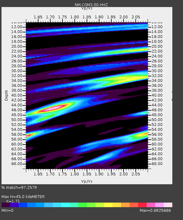
| Estimated Moho Depth: |
45.0 km |
| Estimated Crust Vp/Vs: |
1.71 |
| Assumed Crust Vp: |
6.444 km/s |
| Estimated Crust Vs: |
3.768 km/s |
| Estimated Crust Poisson's Ratio: |
0.24 |
|
| Radial Match: |
97.2579 % |
| Radial Bump: |
358 |
| Transverse Match: |
86.02535 % |
| Transverse Bump: |
400 |
| SOD ConfigId: |
1427151 |
| Insert Time: |
2016-02-13 04:14:35.267 +0000 |
| GWidth: |
2.5 |
| Max Bumps: |
400 |
| Tol: |
0.001 |
|

Signal To Noise
| Channel | StoN | STA | LTA |
| NM:CGM3:00:HHZ:20160130T03:35:44.578997Z | 41.321156 | 1.422108E-5 | 3.4415982E-7 |
| NM:CGM3:00:HHN:20160130T03:35:44.578997Z | 24.131472 | 5.652364E-6 | 2.3423205E-7 |
| NM:CGM3:00:HHE:20160130T03:35:44.578997Z | 10.337895 | 3.81613E-6 | 3.6913997E-7 |
| Arrivals |
| Ps | 5.1 SECOND |
| PpPs | 18 SECOND |
| PsPs/PpSs | 23 SECOND |


