You are here: Home > Network List > TA - USArray Transportable Network (new EarthScope stations) Stations List
> Station O05C Quincy, CA, USA > Earthquake Result Viewer
O05C Quincy, CA, USA - Earthquake Result Viewer

| Earthquake location: |
Tonga Islands |
| Earthquake latitude/longitude: |
-15.2/-173.6 |
| Earthquake time(UTC): |
2006/07/07 (188) 07:26:12 GMT |
| Earthquake Depth: |
35 km |
| Earthquake Magnitude: |
5.7 MB, 5.9 MS, 6.0 MW, 6.0 MW |
| Earthquake Catalog/Contributor: |
WHDF/NEIC |
|
| Network: |
TA USArray Transportable Network (new EarthScope stations) |
| Station: |
O05C Quincy, CA, USA |
| Lat/Lon: |
39.96 N/120.92 W |
| Elevation: |
1032 m |
|
| Distance: |
73.6 deg |
| Az: |
39.59 deg |
| Baz: |
233.165 deg |
| Ray Param: |
0.052849747 |
| Estimated Moho Depth: |
37.5 km |
| Estimated Crust Vp/Vs: |
1.85 |
| Assumed Crust Vp: |
6.597 km/s |
| Estimated Crust Vs: |
3.571 km/s |
| Estimated Crust Poisson's Ratio: |
0.29 |
|
| Radial Match: |
90.68037 % |
| Radial Bump: |
400 |
| Transverse Match: |
77.48361 % |
| Transverse Bump: |
400 |
| SOD ConfigId: |
2665 |
| Insert Time: |
2010-03-06 03:01:30.181 +0000 |
| GWidth: |
2.5 |
| Max Bumps: |
400 |
| Tol: |
0.001 |
|
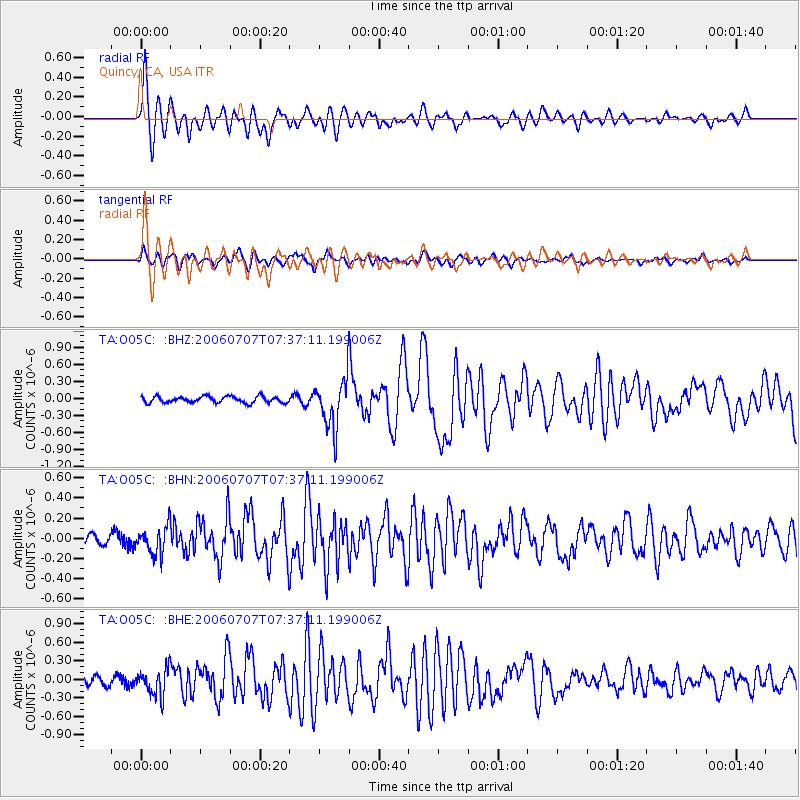
Signal To Noise
| Channel | StoN | STA | LTA |
| TA:O05C: :BHN:20060707T07:37:11.199006Z | 2.2035272 | 1.3646E-7 | 6.192799E-8 |
| TA:O05C: :BHE:20060707T07:37:11.199006Z | 2.7936144 | 2.1889592E-7 | 7.835581E-8 |
| TA:O05C: :BHZ:20060707T07:37:11.199006Z | 7.8432937 | 4.331294E-7 | 5.52229E-8 |
| Arrivals |
| Ps | 5.0 SECOND |
| PpPs | 16 SECOND |
| PsPs/PpSs | 21 SECOND |


