You are here: Home > Network List > AV - Alaska Volcano Observatory Stations List
> Station SPCR Ckakachatna River, Mount Spurr, Alaska > Earthquake Result Viewer
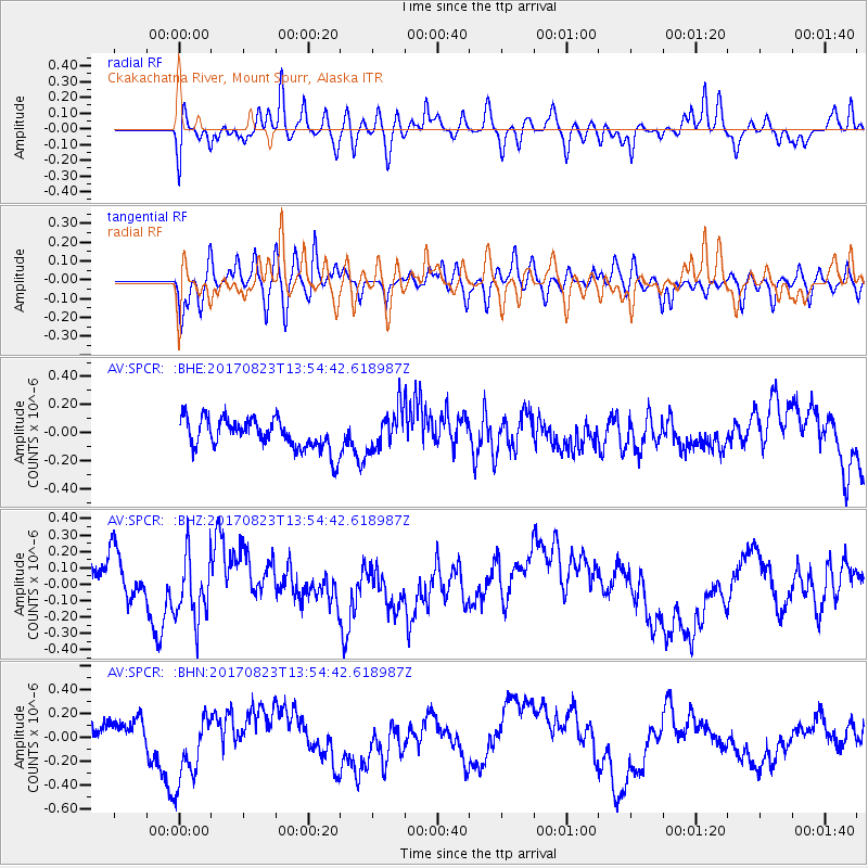
SPCR Ckakachatna River, Mount Spurr, Alaska - Earthquake Result Viewer
*The percent match for this event was below the threshold and hence no stack was calculated.
| Earthquake location: |
Iran-Iraq Border Region |
| Earthquake latitude/longitude: |
36.2/45.0 |
| Earthquake time(UTC): |
2017/08/23 (235) 13:42:53 GMT |
| Earthquake Depth: |
10 km |
| Earthquake Magnitude: |
5.6 mb |
| Earthquake Catalog/Contributor: |
NEIC PDE/us |
|
| Network: |
AV Alaska Volcano Observatory |
| Station: |
SPCR Ckakachatna River, Mount Spurr, Alaska |
| Lat/Lon: |
61.20 N/152.21 W |
| Elevation: |
984 m |
|
| Distance: |
82.0 deg |
| Az: |
8.306 deg |
| Baz: |
346.028 deg |
| Ray Param: |
$rayparam |
*The percent match for this event was below the threshold and hence was not used in the summary stack. |
|
| Radial Match: |
47.762302 % |
| Radial Bump: |
400 |
| Transverse Match: |
55.595345 % |
| Transverse Bump: |
400 |
| SOD ConfigId: |
13570011 |
| Insert Time: |
2019-04-28 15:24:33.800 +0000 |
| GWidth: |
2.5 |
| Max Bumps: |
400 |
| Tol: |
0.001 |
|
Signal To Noise
| Channel | StoN | STA | LTA |
| AV:SPCR: :BHZ:20170823T13:54:42.618987Z | 1.2916137 | 1.9328812E-7 | 1.4964854E-7 |
| AV:SPCR: :BHN:20170823T13:54:42.618987Z | 2.864343 | 3.0658254E-7 | 1.07034154E-7 |
| AV:SPCR: :BHE:20170823T13:54:42.618987Z | 1.2824466 | 1.3916598E-7 | 1.0851599E-7 |
| Arrivals |
| Ps | |
| PpPs | |
| PsPs/PpSs | |


