You are here: Home > Network List > TA - USArray Transportable Network (new EarthScope stations) Stations List
> Station 124A Stringfield Ranch, Weed, NM, USA > Earthquake Result Viewer
124A Stringfield Ranch, Weed, NM, USA - Earthquake Result Viewer
| Earthquake location: |
Loyalty Islands |
| Earthquake latitude/longitude: |
-20.1/168.9 |
| Earthquake time(UTC): |
2008/04/09 (100) 12:46:12 GMT |
| Earthquake Depth: |
33 km |
| Earthquake Magnitude: |
6.3 MB, 7.3 MS, 7.3 MW, 7.3 MW |
| Earthquake Catalog/Contributor: |
WHDF/NEIC |
|
| Network: |
TA USArray Transportable Network (new EarthScope stations) |
| Station: |
124A Stringfield Ranch, Weed, NM, USA |
| Lat/Lon: |
32.70 N/105.45 W |
| Elevation: |
2078 m |
|
| Distance: |
97.1 deg |
| Az: |
57.908 deg |
| Baz: |
250.825 deg |
| Ray Param: |
0.040304106 |
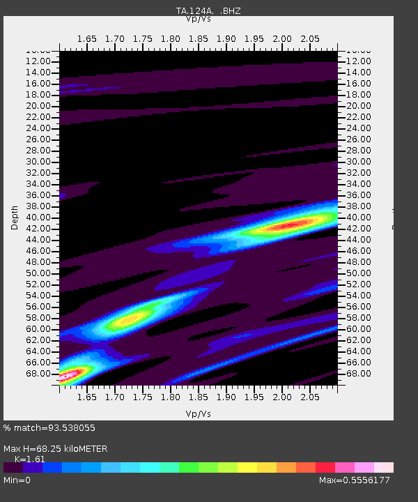
| Estimated Moho Depth: |
68.25 km |
| Estimated Crust Vp/Vs: |
1.61 |
| Assumed Crust Vp: |
6.232 km/s |
| Estimated Crust Vs: |
3.871 km/s |
| Estimated Crust Poisson's Ratio: |
0.19 |
|
| Radial Match: |
93.538055 % |
| Radial Bump: |
286 |
| Transverse Match: |
84.73702 % |
| Transverse Bump: |
341 |
| SOD ConfigId: |
2504 |
| Insert Time: |
2010-03-06 03:02:13.449 +0000 |
| GWidth: |
2.5 |
| Max Bumps: |
400 |
| Tol: |
0.001 |
|
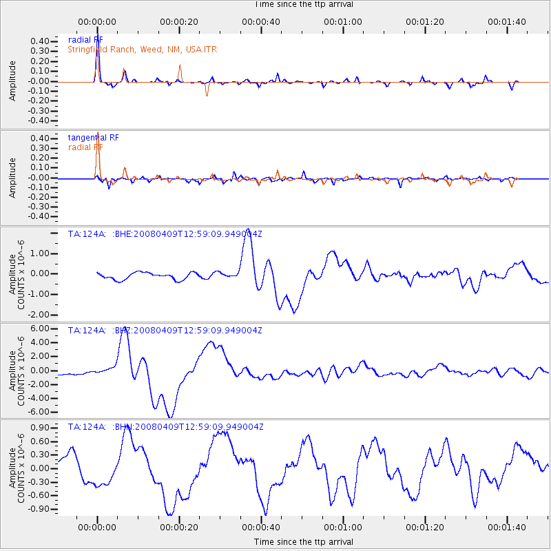
Signal To Noise
| Channel | StoN | STA | LTA |
| TA:124A: :BHZ:20080409T12:59:09.949004Z | 2.1366048 | 5.7305454E-7 | 2.68208E-7 |
| TA:124A: :BHN:20080409T12:59:09.949004Z | 1.5797449 | 3.3142604E-7 | 2.097972E-7 |
| TA:124A: :BHE:20080409T12:59:09.949004Z | 0.89229196 | 1.4884617E-7 | 1.6681331E-7 |
| Arrivals |
| Ps | 6.8 SECOND |
| PpPs | 28 SECOND |
| PsPs/PpSs | 35 SECOND |


