You are here: Home > Network List > TA - USArray Transportable Network (new EarthScope stations) Stations List
> Station E20K Nigu River, AK, USA > Earthquake Result Viewer
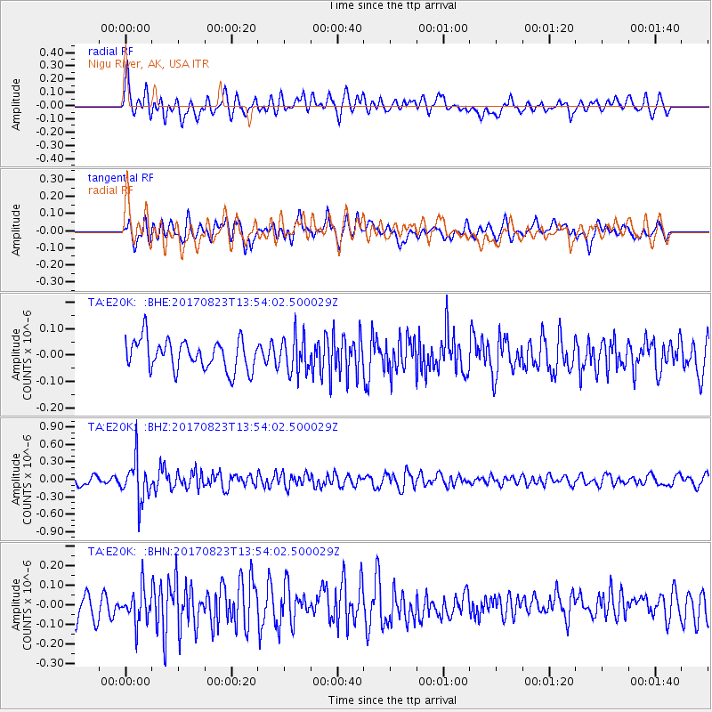
E20K Nigu River, AK, USA - Earthquake Result Viewer
*The percent match for this event was below the threshold and hence no stack was calculated.
| Earthquake location: |
Iran-Iraq Border Region |
| Earthquake latitude/longitude: |
36.2/45.0 |
| Earthquake time(UTC): |
2017/08/23 (235) 13:42:53 GMT |
| Earthquake Depth: |
10 km |
| Earthquake Magnitude: |
5.6 mb |
| Earthquake Catalog/Contributor: |
NEIC PDE/us |
|
| Network: |
TA USArray Transportable Network (new EarthScope stations) |
| Station: |
E20K Nigu River, AK, USA |
| Lat/Lon: |
68.26 N/156.19 W |
| Elevation: |
866 m |
|
| Distance: |
74.7 deg |
| Az: |
8.016 deg |
| Baz: |
342.368 deg |
| Ray Param: |
$rayparam |
*The percent match for this event was below the threshold and hence was not used in the summary stack. |
|
| Radial Match: |
62.71025 % |
| Radial Bump: |
400 |
| Transverse Match: |
54.20122 % |
| Transverse Bump: |
400 |
| SOD ConfigId: |
13570011 |
| Insert Time: |
2019-04-28 15:28:40.800 +0000 |
| GWidth: |
2.5 |
| Max Bumps: |
400 |
| Tol: |
0.001 |
|
Signal To Noise
| Channel | StoN | STA | LTA |
| TA:E20K: :BHZ:20170823T13:54:02.500029Z | 4.459744 | 3.560276E-7 | 7.98314E-8 |
| TA:E20K: :BHN:20170823T13:54:02.500029Z | 1.4125445 | 8.626408E-8 | 6.106999E-8 |
| TA:E20K: :BHE:20170823T13:54:02.500029Z | 1.2065681 | 6.869577E-8 | 5.6934844E-8 |
| Arrivals |
| Ps | |
| PpPs | |
| PsPs/PpSs | |


