You are here: Home > Network List > OK - Oklahoma Seismic Network Stations List
> Station FNO Franklin, Norman, OK > Earthquake Result Viewer
FNO Franklin, Norman, OK - Earthquake Result Viewer
| Earthquake location: |
Kamchatka Peninsula, Russia |
| Earthquake latitude/longitude: |
54.0/158.5 |
| Earthquake time(UTC): |
2016/01/30 (030) 03:25:10 GMT |
| Earthquake Depth: |
161 km |
| Earthquake Magnitude: |
7.2 MWW, 7.0 MI, 7.2 MWB |
| Earthquake Catalog/Contributor: |
NEIC PDE/NEIC COMCAT |
|
| Network: |
OK Oklahoma Seismic Network |
| Station: |
FNO Franklin, Norman, OK |
| Lat/Lon: |
35.26 N/97.40 W |
| Elevation: |
360 m |
|
| Distance: |
69.7 deg |
| Az: |
57.79 deg |
| Baz: |
322.392 deg |
| Ray Param: |
0.05500469 |
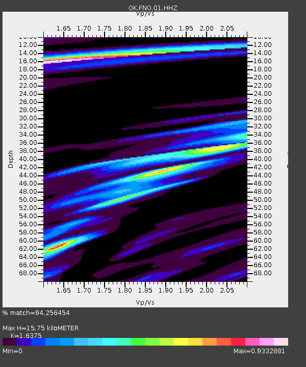
| Estimated Moho Depth: |
15.75 km |
| Estimated Crust Vp/Vs: |
1.64 |
| Assumed Crust Vp: |
6.426 km/s |
| Estimated Crust Vs: |
3.924 km/s |
| Estimated Crust Poisson's Ratio: |
0.20 |
|
| Radial Match: |
94.256454 % |
| Radial Bump: |
366 |
| Transverse Match: |
80.89446 % |
| Transverse Bump: |
386 |
| SOD ConfigId: |
1427151 |
| Insert Time: |
2016-02-13 04:16:19.759 +0000 |
| GWidth: |
2.5 |
| Max Bumps: |
400 |
| Tol: |
0.001 |
|

Signal To Noise
| Channel | StoN | STA | LTA |
| OK:FNO:01:HHZ:20160130T03:35:32.060015Z | 43.08075 | 5.6555553E-5 | 1.3127801E-6 |
| OK:FNO:01:HHN:20160130T03:35:32.060015Z | 9.193616 | 1.8172244E-5 | 1.9766155E-6 |
| OK:FNO:01:HHE:20160130T03:35:32.060015Z | 8.047661 | 1.4715873E-5 | 1.8285901E-6 |
| Arrivals |
| Ps | 1.6 SECOND |
| PpPs | 6.2 SECOND |
| PsPs/PpSs | 7.8 SECOND |


