You are here: Home > Network List > TA - USArray Transportable Network (new EarthScope stations) Stations List
> Station H31M Peel River, Yukon, CAN > Earthquake Result Viewer
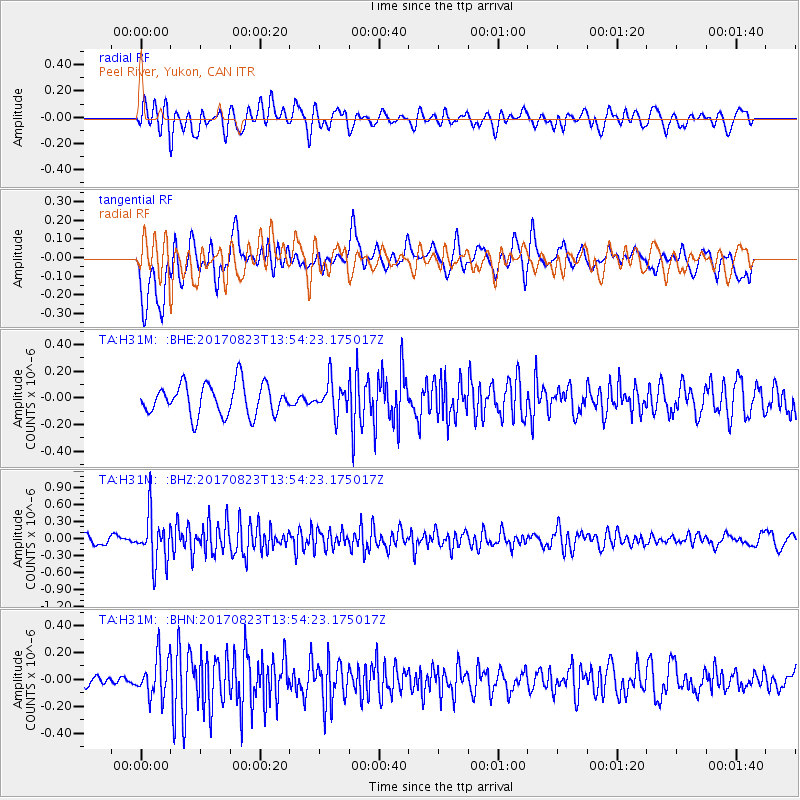
H31M Peel River, Yukon, CAN - Earthquake Result Viewer
*The percent match for this event was below the threshold and hence no stack was calculated.
| Earthquake location: |
Iran-Iraq Border Region |
| Earthquake latitude/longitude: |
36.2/45.0 |
| Earthquake time(UTC): |
2017/08/23 (235) 13:42:53 GMT |
| Earthquake Depth: |
10 km |
| Earthquake Magnitude: |
5.6 mb |
| Earthquake Catalog/Contributor: |
NEIC PDE/us |
|
| Network: |
TA USArray Transportable Network (new EarthScope stations) |
| Station: |
H31M Peel River, Yukon, CAN |
| Lat/Lon: |
65.81 N/134.34 W |
| Elevation: |
642 m |
|
| Distance: |
78.4 deg |
| Az: |
359.712 deg |
| Baz: |
0.566 deg |
| Ray Param: |
$rayparam |
*The percent match for this event was below the threshold and hence was not used in the summary stack. |
|
| Radial Match: |
61.70648 % |
| Radial Bump: |
400 |
| Transverse Match: |
64.75895 % |
| Transverse Bump: |
400 |
| SOD ConfigId: |
13570011 |
| Insert Time: |
2019-04-28 15:29:16.373 +0000 |
| GWidth: |
2.5 |
| Max Bumps: |
400 |
| Tol: |
0.001 |
|
Signal To Noise
| Channel | StoN | STA | LTA |
| TA:H31M: :BHZ:20170823T13:54:23.175017Z | 4.8376346 | 4.3347785E-7 | 8.960534E-8 |
| TA:H31M: :BHN:20170823T13:54:23.175017Z | 2.1537597 | 1.4899409E-7 | 6.9178604E-8 |
| TA:H31M: :BHE:20170823T13:54:23.175017Z | 1.0059005 | 1.1740717E-7 | 1.1671847E-7 |
| Arrivals |
| Ps | |
| PpPs | |
| PsPs/PpSs | |


