You are here: Home > Network List > TA - USArray Transportable Network (new EarthScope stations) Stations List
> Station I23K Minto, Yukon-Koyukuk, AK, USA > Earthquake Result Viewer
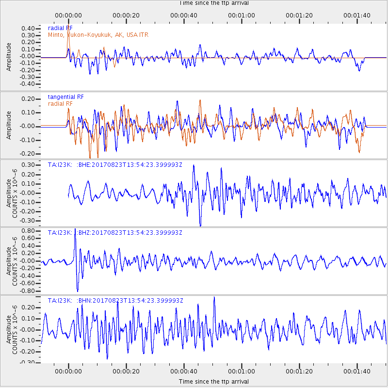
I23K Minto, Yukon-Koyukuk, AK, USA - Earthquake Result Viewer
*The percent match for this event was below the threshold and hence no stack was calculated.
| Earthquake location: |
Iran-Iraq Border Region |
| Earthquake latitude/longitude: |
36.2/45.0 |
| Earthquake time(UTC): |
2017/08/23 (235) 13:42:53 GMT |
| Earthquake Depth: |
10 km |
| Earthquake Magnitude: |
5.6 mb |
| Earthquake Catalog/Contributor: |
NEIC PDE/us |
|
| Network: |
TA USArray Transportable Network (new EarthScope stations) |
| Station: |
I23K Minto, Yukon-Koyukuk, AK, USA |
| Lat/Lon: |
65.15 N/149.36 W |
| Elevation: |
149 m |
|
| Distance: |
78.4 deg |
| Az: |
6.131 deg |
| Baz: |
348.198 deg |
| Ray Param: |
$rayparam |
*The percent match for this event was below the threshold and hence was not used in the summary stack. |
|
| Radial Match: |
52.072056 % |
| Radial Bump: |
400 |
| Transverse Match: |
53.537422 % |
| Transverse Bump: |
400 |
| SOD ConfigId: |
13570011 |
| Insert Time: |
2019-04-28 15:29:18.922 +0000 |
| GWidth: |
2.5 |
| Max Bumps: |
400 |
| Tol: |
0.001 |
|
Signal To Noise
| Channel | StoN | STA | LTA |
| TA:I23K: :BHZ:20170823T13:54:23.399993Z | 6.1158047 | 3.6316507E-7 | 5.9381406E-8 |
| TA:I23K: :BHN:20170823T13:54:23.399993Z | 1.2204555 | 9.2034185E-8 | 7.54097E-8 |
| TA:I23K: :BHE:20170823T13:54:23.399993Z | 1.243679 | 6.6041444E-8 | 5.3101676E-8 |
| Arrivals |
| Ps | |
| PpPs | |
| PsPs/PpSs | |


