You are here: Home > Network List > TA - USArray Transportable Network (new EarthScope stations) Stations List
> Station 124A Stringfield Ranch, Weed, NM, USA > Earthquake Result Viewer
124A Stringfield Ranch, Weed, NM, USA - Earthquake Result Viewer
| Earthquake location: |
Hokkaido, Japan Region |
| Earthquake latitude/longitude: |
41.9/143.8 |
| Earthquake time(UTC): |
2008/09/11 (255) 00:20:50 GMT |
| Earthquake Depth: |
25 km |
| Earthquake Magnitude: |
6.1 MB, 7.0 MS, 6.8 MW, 6.8 MW |
| Earthquake Catalog/Contributor: |
WHDF/NEIC |
|
| Network: |
TA USArray Transportable Network (new EarthScope stations) |
| Station: |
124A Stringfield Ranch, Weed, NM, USA |
| Lat/Lon: |
32.70 N/105.45 W |
| Elevation: |
2078 m |
|
| Distance: |
82.3 deg |
| Az: |
52.697 deg |
| Baz: |
315.22 deg |
| Ray Param: |
0.0469645 |
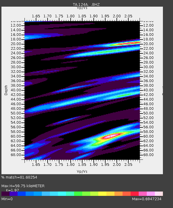
| Estimated Moho Depth: |
59.75 km |
| Estimated Crust Vp/Vs: |
1.97 |
| Assumed Crust Vp: |
6.232 km/s |
| Estimated Crust Vs: |
3.163 km/s |
| Estimated Crust Poisson's Ratio: |
0.33 |
|
| Radial Match: |
81.68254 % |
| Radial Bump: |
350 |
| Transverse Match: |
74.2068 % |
| Transverse Bump: |
400 |
| SOD ConfigId: |
2560 |
| Insert Time: |
2010-03-06 03:02:59.141 +0000 |
| GWidth: |
2.5 |
| Max Bumps: |
400 |
| Tol: |
0.001 |
|
Signal To Noise
| Channel | StoN | STA | LTA |
| TA:124A: :BHZ:20080911T00:32:38.849016Z | 1.5017217 | 6.543621E-7 | 4.3574127E-7 |
| TA:124A: :BHN:20080911T00:32:38.849016Z | 0.90558714 | 2.783662E-7 | 3.0738752E-7 |
| TA:124A: :BHE:20080911T00:32:38.849016Z | 1.1095757 | 4.4892633E-7 | 4.0459278E-7 |
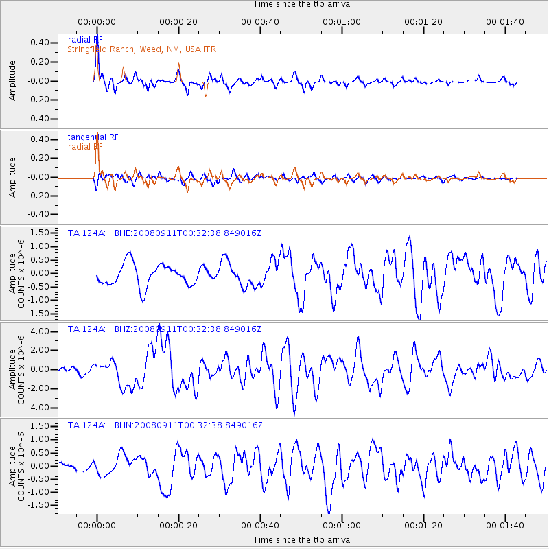
| Arrivals |
| Ps | 9.5 SECOND |
| PpPs | 28 SECOND |
| PsPs/PpSs | 37 SECOND |


