You are here: Home > Network List > TA - USArray Transportable Network (new EarthScope stations) Stations List
> Station O18K Koktuh Hills, AK, USA > Earthquake Result Viewer
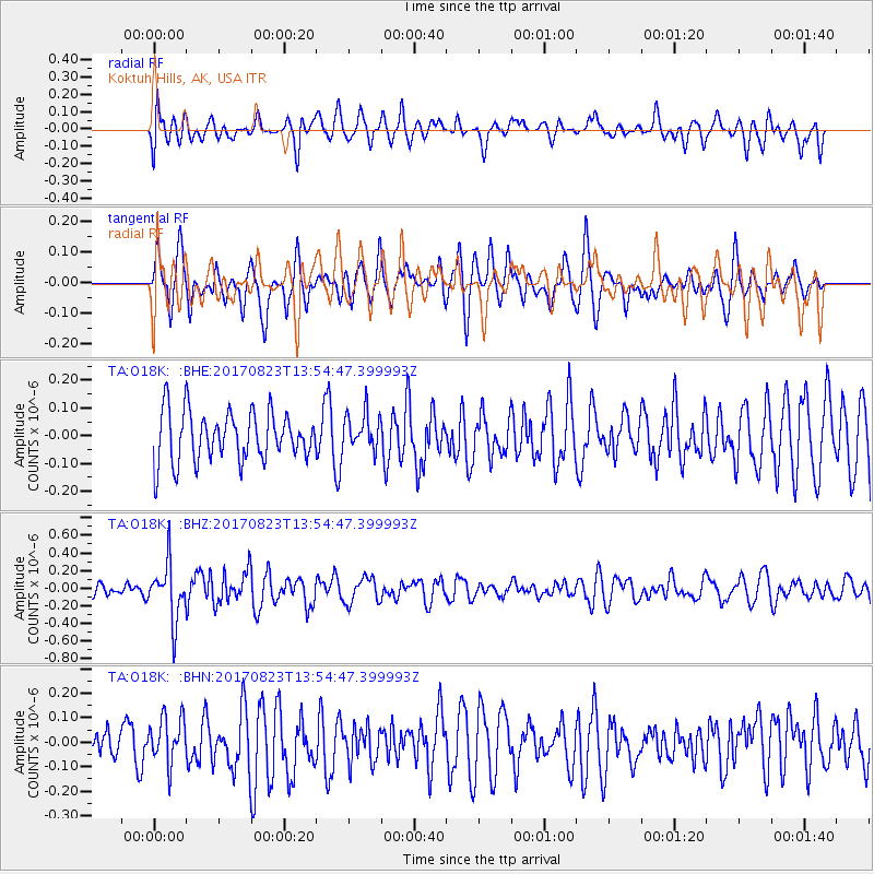
O18K Koktuh Hills, AK, USA - Earthquake Result Viewer
*The percent match for this event was below the threshold and hence no stack was calculated.
| Earthquake location: |
Iran-Iraq Border Region |
| Earthquake latitude/longitude: |
36.2/45.0 |
| Earthquake time(UTC): |
2017/08/23 (235) 13:42:53 GMT |
| Earthquake Depth: |
10 km |
| Earthquake Magnitude: |
5.6 mb |
| Earthquake Catalog/Contributor: |
NEIC PDE/us |
|
| Network: |
TA USArray Transportable Network (new EarthScope stations) |
| Station: |
O18K Koktuh Hills, AK, USA |
| Lat/Lon: |
59.85 N/155.21 W |
| Elevation: |
544 m |
|
| Distance: |
82.9 deg |
| Az: |
10.106 deg |
| Baz: |
343.658 deg |
| Ray Param: |
$rayparam |
*The percent match for this event was below the threshold and hence was not used in the summary stack. |
|
| Radial Match: |
49.764412 % |
| Radial Bump: |
400 |
| Transverse Match: |
52.178112 % |
| Transverse Bump: |
400 |
| SOD ConfigId: |
13570011 |
| Insert Time: |
2019-04-28 15:30:02.638 +0000 |
| GWidth: |
2.5 |
| Max Bumps: |
400 |
| Tol: |
0.001 |
|
Signal To Noise
| Channel | StoN | STA | LTA |
| TA:O18K: :BHZ:20170823T13:54:47.399993Z | 4.4819827 | 3.2463177E-7 | 7.2430396E-8 |
| TA:O18K: :BHN:20170823T13:54:47.399993Z | 1.0184083 | 9.415247E-8 | 9.2450605E-8 |
| TA:O18K: :BHE:20170823T13:54:47.399993Z | 0.74470645 | 6.703776E-8 | 9.0019036E-8 |
| Arrivals |
| Ps | |
| PpPs | |
| PsPs/PpSs | |


