You are here: Home > Network List > TJ - Tajikistan National Seismic Network Stations List
> Station MANEM Manem, Tajikistan > Earthquake Result Viewer
MANEM Manem, Tajikistan - Earthquake Result Viewer
| Earthquake location: |
South Of Java, Indonesia |
| Earthquake latitude/longitude: |
-10.4/111.1 |
| Earthquake time(UTC): |
2017/08/27 (239) 00:02:23 GMT |
| Earthquake Depth: |
20 km |
| Earthquake Magnitude: |
5.5 mb |
| Earthquake Catalog/Contributor: |
NEIC PDE/us |
|
| Network: |
TJ Tajikistan National Seismic Network |
| Station: |
MANEM Manem, Tajikistan |
| Lat/Lon: |
37.53 N/71.66 E |
| Elevation: |
2312 m |
|
| Distance: |
60.3 deg |
| Az: |
324.475 deg |
| Baz: |
134.024 deg |
| Ray Param: |
0.061605178 |
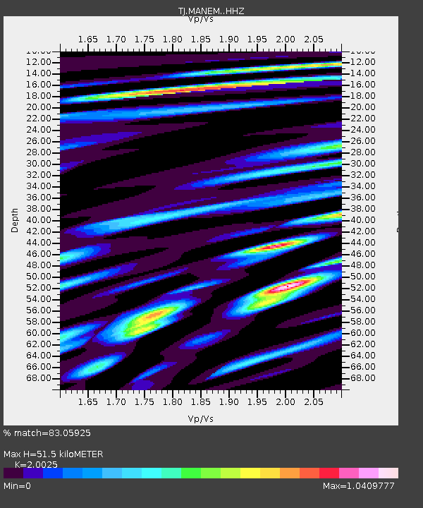
| Estimated Moho Depth: |
51.5 km |
| Estimated Crust Vp/Vs: |
2.00 |
| Assumed Crust Vp: |
6.306 km/s |
| Estimated Crust Vs: |
3.149 km/s |
| Estimated Crust Poisson's Ratio: |
0.33 |
|
| Radial Match: |
83.05925 % |
| Radial Bump: |
400 |
| Transverse Match: |
75.76442 % |
| Transverse Bump: |
400 |
| SOD ConfigId: |
13570011 |
| Insert Time: |
2019-04-28 15:34:44.737 +0000 |
| GWidth: |
2.5 |
| Max Bumps: |
400 |
| Tol: |
0.001 |
|

Signal To Noise
| Channel | StoN | STA | LTA |
| TJ:MANEM: :HHZ:20170827T00:11:59.720Z | 9.788528 | 7.41308E-7 | 7.573232E-8 |
| TJ:MANEM: :HHN:20170827T00:11:59.720Z | 2.6745052 | 2.3343998E-7 | 8.728343E-8 |
| TJ:MANEM: :HHE:20170827T00:11:59.720Z | 2.427957 | 2.5116603E-7 | 1.03447476E-7 |
| Arrivals |
| Ps | 8.5 SECOND |
| PpPs | 24 SECOND |
| PsPs/PpSs | 32 SECOND |


