You are here: Home > Network List > TA - USArray Transportable Network (new EarthScope stations) Stations List
> Station 124A Stringfield Ranch, Weed, NM, USA > Earthquake Result Viewer
124A Stringfield Ranch, Weed, NM, USA - Earthquake Result Viewer
| Earthquake location: |
Rat Islands, Aleutian Islands |
| Earthquake latitude/longitude: |
50.4/177.0 |
| Earthquake time(UTC): |
2009/07/06 (187) 14:53:12 GMT |
| Earthquake Depth: |
22 km |
| Earthquake Magnitude: |
6.0 MB, 5.8 MS, 6.1 MW, 6.0 MW |
| Earthquake Catalog/Contributor: |
WHDF/NEIC |
|
| Network: |
TA USArray Transportable Network (new EarthScope stations) |
| Station: |
124A Stringfield Ranch, Weed, NM, USA |
| Lat/Lon: |
32.70 N/105.45 W |
| Elevation: |
2078 m |
|
| Distance: |
58.0 deg |
| Az: |
76.075 deg |
| Baz: |
312.594 deg |
| Ray Param: |
0.06308617 |
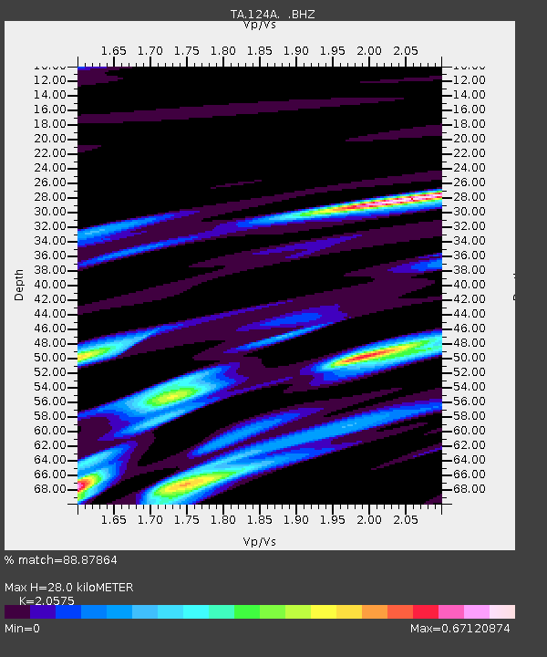
| Estimated Moho Depth: |
28.0 km |
| Estimated Crust Vp/Vs: |
2.06 |
| Assumed Crust Vp: |
6.232 km/s |
| Estimated Crust Vs: |
3.029 km/s |
| Estimated Crust Poisson's Ratio: |
0.35 |
|
| Radial Match: |
88.87864 % |
| Radial Bump: |
368 |
| Transverse Match: |
68.15573 % |
| Transverse Bump: |
400 |
| SOD ConfigId: |
2648 |
| Insert Time: |
2010-03-06 03:03:57.453 +0000 |
| GWidth: |
2.5 |
| Max Bumps: |
400 |
| Tol: |
0.001 |
|
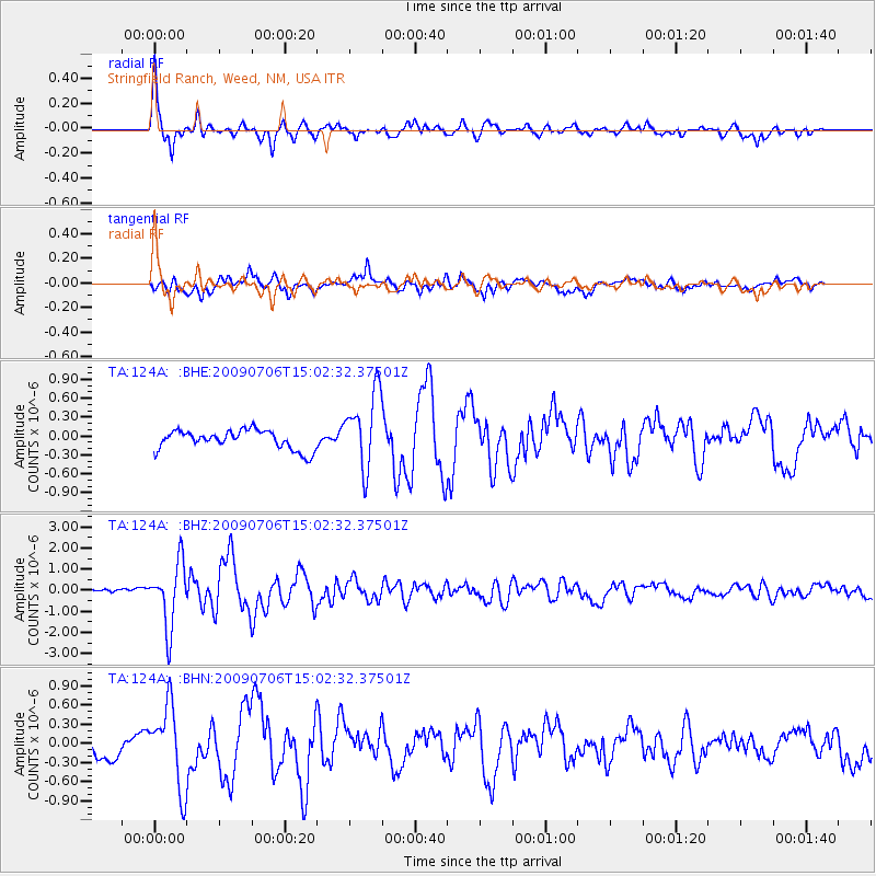
Signal To Noise
| Channel | StoN | STA | LTA |
| TA:124A: :BHZ:20090706T15:02:32.37501Z | 9.29573 | 1.5115888E-6 | 1.626111E-7 |
| TA:124A: :BHN:20090706T15:02:32.37501Z | 4.6419735 | 6.3252236E-7 | 1.3626152E-7 |
| TA:124A: :BHE:20090706T15:02:32.37501Z | 3.9849272 | 6.0813267E-7 | 1.5260822E-7 |
| Arrivals |
| Ps | 4.9 SECOND |
| PpPs | 13 SECOND |
| PsPs/PpSs | 18 SECOND |


