You are here: Home > Network List > TA - USArray Transportable Network (new EarthScope stations) Stations List
> Station 124A Stringfield Ranch, Weed, NM, USA > Earthquake Result Viewer
124A Stringfield Ranch, Weed, NM, USA - Earthquake Result Viewer
| Earthquake location: |
Kodiak Island Region, Alaska |
| Earthquake latitude/longitude: |
56.5/-152.7 |
| Earthquake time(UTC): |
2009/03/30 (089) 07:13:07 GMT |
| Earthquake Depth: |
21 km |
| Earthquake Magnitude: |
5.9 MB, 5.9 MS, 5.9 MW, 5.9 MW |
| Earthquake Catalog/Contributor: |
WHDF/NEIC |
|
| Network: |
TA USArray Transportable Network (new EarthScope stations) |
| Station: |
124A Stringfield Ranch, Weed, NM, USA |
| Lat/Lon: |
32.70 N/105.45 W |
| Elevation: |
2078 m |
|
| Distance: |
40.1 deg |
| Az: |
106.064 deg |
| Baz: |
320.859 deg |
| Ray Param: |
0.07453437 |
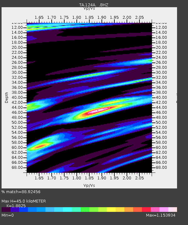
| Estimated Moho Depth: |
45.0 km |
| Estimated Crust Vp/Vs: |
1.88 |
| Assumed Crust Vp: |
6.232 km/s |
| Estimated Crust Vs: |
3.31 km/s |
| Estimated Crust Poisson's Ratio: |
0.30 |
|
| Radial Match: |
88.92456 % |
| Radial Bump: |
400 |
| Transverse Match: |
65.07667 % |
| Transverse Bump: |
372 |
| SOD ConfigId: |
2658 |
| Insert Time: |
2010-03-06 03:04:00.707 +0000 |
| GWidth: |
2.5 |
| Max Bumps: |
400 |
| Tol: |
0.001 |
|
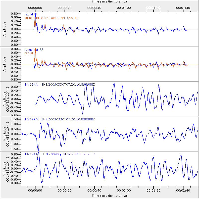
Signal To Noise
| Channel | StoN | STA | LTA |
| TA:124A: :BHZ:20090330T07:20:10.898988Z | 8.395613 | 8.173984E-7 | 9.7360186E-8 |
| TA:124A: :BHN:20090330T07:20:10.898988Z | 6.6083837 | 5.1169025E-7 | 7.743047E-8 |
| TA:124A: :BHE:20090330T07:20:10.898988Z | 3.4118419 | 4.5542805E-7 | 1.3348452E-7 |
| Arrivals |
| Ps | 6.8 SECOND |
| PpPs | 20 SECOND |
| PsPs/PpSs | 26 SECOND |


