You are here: Home > Network List > AK - Alaska Regional Network Stations List
> Station CAST Castle Rocks > Earthquake Result Viewer
CAST Castle Rocks - Earthquake Result Viewer
| Earthquake location: |
Admiralty Islands Region, P.N.G. |
| Earthquake latitude/longitude: |
-1.4/148.1 |
| Earthquake time(UTC): |
2017/08/27 (239) 04:17:51 GMT |
| Earthquake Depth: |
10 km |
| Earthquake Magnitude: |
6.6 Mi |
| Earthquake Catalog/Contributor: |
NEIC PDE/at |
|
| Network: |
AK Alaska Regional Network |
| Station: |
CAST Castle Rocks |
| Lat/Lon: |
63.42 N/152.08 W |
| Elevation: |
611 m |
|
| Distance: |
78.2 deg |
| Az: |
23.407 deg |
| Baz: |
241.985 deg |
| Ray Param: |
0.049800914 |
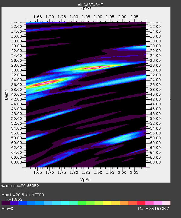
| Estimated Moho Depth: |
28.5 km |
| Estimated Crust Vp/Vs: |
1.90 |
| Assumed Crust Vp: |
6.566 km/s |
| Estimated Crust Vs: |
3.447 km/s |
| Estimated Crust Poisson's Ratio: |
0.31 |
|
| Radial Match: |
89.66052 % |
| Radial Bump: |
338 |
| Transverse Match: |
73.82916 % |
| Transverse Bump: |
336 |
| SOD ConfigId: |
13570011 |
| Insert Time: |
2019-04-28 15:35:23.485 +0000 |
| GWidth: |
2.5 |
| Max Bumps: |
400 |
| Tol: |
0.001 |
|

Signal To Noise
| Channel | StoN | STA | LTA |
| AK:CAST: :BHZ:20170827T04:29:19.867981Z | 3.0221155 | 2.1953548E-7 | 7.2642976E-8 |
| AK:CAST: :BHN:20170827T04:29:19.867981Z | 1.3463191 | 8.614303E-8 | 6.398412E-8 |
| AK:CAST: :BHE:20170827T04:29:19.867981Z | 1.0770923 | 1.0703629E-7 | 9.937523E-8 |
| Arrivals |
| Ps | 4.0 SECOND |
| PpPs | 12 SECOND |
| PsPs/PpSs | 16 SECOND |


