You are here: Home > Network List > AV - Alaska Volcano Observatory Stations List
> Station AMKA Regional Station, Amchitka Island, Alaska > Earthquake Result Viewer
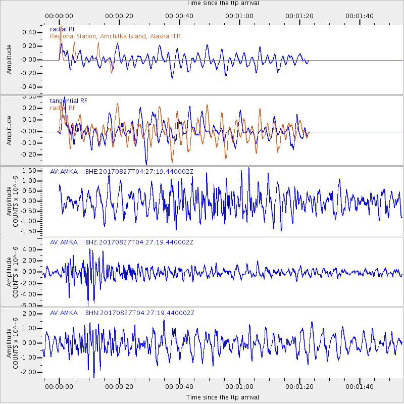
AMKA Regional Station, Amchitka Island, Alaska - Earthquake Result Viewer
*The percent match for this event was below the threshold and hence no stack was calculated.
| Earthquake location: |
Admiralty Islands Region, P.N.G. |
| Earthquake latitude/longitude: |
-1.4/148.1 |
| Earthquake time(UTC): |
2017/08/27 (239) 04:17:51 GMT |
| Earthquake Depth: |
10 km |
| Earthquake Magnitude: |
6.6 Mi |
| Earthquake Catalog/Contributor: |
NEIC PDE/at |
|
| Network: |
AV Alaska Volcano Observatory |
| Station: |
AMKA Regional Station, Amchitka Island, Alaska |
| Lat/Lon: |
51.38 N/179.30 E |
| Elevation: |
116 m |
|
| Distance: |
58.9 deg |
| Az: |
22.291 deg |
| Baz: |
217.232 deg |
| Ray Param: |
$rayparam |
*The percent match for this event was below the threshold and hence was not used in the summary stack. |
|
| Radial Match: |
62.591747 % |
| Radial Bump: |
400 |
| Transverse Match: |
56.634735 % |
| Transverse Bump: |
397 |
| SOD ConfigId: |
13570011 |
| Insert Time: |
2019-04-28 15:36:08.602 +0000 |
| GWidth: |
2.5 |
| Max Bumps: |
400 |
| Tol: |
0.001 |
|
Signal To Noise
| Channel | StoN | STA | LTA |
| AV:AMKA: :BHZ:20170827T04:27:19.440002Z | 3.1662061 | 1.2797603E-6 | 4.0419363E-7 |
| AV:AMKA: :BHN:20170827T04:27:19.440002Z | 1.327362 | 4.7691435E-7 | 3.592949E-7 |
| AV:AMKA: :BHE:20170827T04:27:19.440002Z | 1.097948 | 5.3292246E-7 | 4.853804E-7 |
| Arrivals |
| Ps | |
| PpPs | |
| PsPs/PpSs | |


