You are here: Home > Network List > CI - Caltech Regional Seismic Network Stations List
> Station GLA Glamis, Glamis, CA, USA > Earthquake Result Viewer
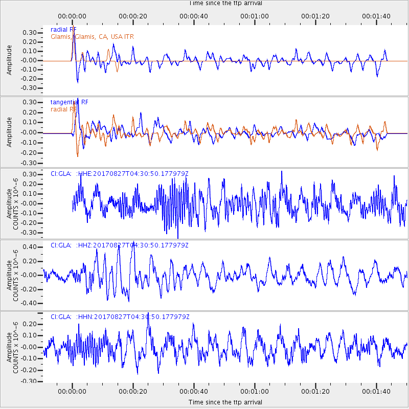
GLA Glamis, Glamis, CA, USA - Earthquake Result Viewer
*The percent match for this event was below the threshold and hence no stack was calculated.
| Earthquake location: |
Admiralty Islands Region, P.N.G. |
| Earthquake latitude/longitude: |
-1.4/148.1 |
| Earthquake time(UTC): |
2017/08/27 (239) 04:17:51 GMT |
| Earthquake Depth: |
10 km |
| Earthquake Magnitude: |
6.6 Mi |
| Earthquake Catalog/Contributor: |
NEIC PDE/at |
|
| Network: |
CI Caltech Regional Seismic Network |
| Station: |
GLA Glamis, Glamis, CA, USA |
| Lat/Lon: |
33.05 N/114.83 W |
| Elevation: |
610 m |
|
| Distance: |
96.7 deg |
| Az: |
57.053 deg |
| Baz: |
272.68 deg |
| Ray Param: |
$rayparam |
*The percent match for this event was below the threshold and hence was not used in the summary stack. |
|
| Radial Match: |
65.95335 % |
| Radial Bump: |
400 |
| Transverse Match: |
67.74537 % |
| Transverse Bump: |
400 |
| SOD ConfigId: |
13570011 |
| Insert Time: |
2019-04-28 15:36:43.855 +0000 |
| GWidth: |
2.5 |
| Max Bumps: |
400 |
| Tol: |
0.001 |
|
Signal To Noise
| Channel | StoN | STA | LTA |
| CI:GLA: :HHZ:20170827T04:30:50.177979Z | 1.5529574 | 9.095494E-8 | 5.8568855E-8 |
| CI:GLA: :HHN:20170827T04:30:50.177979Z | 1.2820989 | 8.013212E-8 | 6.250073E-8 |
| CI:GLA: :HHE:20170827T04:30:50.177979Z | 1.7773135 | 1.5756089E-7 | 8.8651156E-8 |
| Arrivals |
| Ps | |
| PpPs | |
| PsPs/PpSs | |


