You are here: Home > Network List > CN - Canadian National Seismograph Network Stations List
> Station INK INUVIK, NT > Earthquake Result Viewer
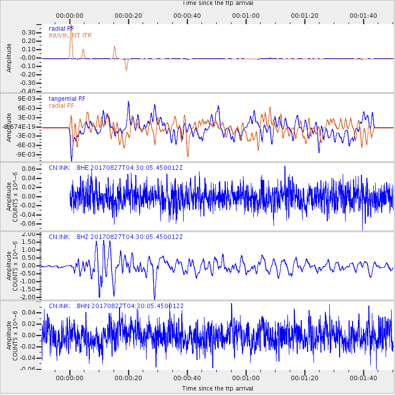
INK INUVIK, NT - Earthquake Result Viewer
*The percent match for this event was below the threshold and hence no stack was calculated.
| Earthquake location: |
Admiralty Islands Region, P.N.G. |
| Earthquake latitude/longitude: |
-1.4/148.1 |
| Earthquake time(UTC): |
2017/08/27 (239) 04:17:51 GMT |
| Earthquake Depth: |
10 km |
| Earthquake Magnitude: |
6.6 Mi |
| Earthquake Catalog/Contributor: |
NEIC PDE/at |
|
| Network: |
CN Canadian National Seismograph Network |
| Station: |
INK INUVIK, NT |
| Lat/Lon: |
68.31 N/133.53 W |
| Elevation: |
44 m |
|
| Distance: |
87.0 deg |
| Az: |
21.387 deg |
| Baz: |
258.679 deg |
| Ray Param: |
$rayparam |
*The percent match for this event was below the threshold and hence was not used in the summary stack. |
|
| Radial Match: |
48.677322 % |
| Radial Bump: |
400 |
| Transverse Match: |
43.969837 % |
| Transverse Bump: |
400 |
| SOD ConfigId: |
13570011 |
| Insert Time: |
2019-04-28 15:37:09.793 +0000 |
| GWidth: |
2.5 |
| Max Bumps: |
400 |
| Tol: |
0.001 |
|
Signal To Noise
| Channel | StoN | STA | LTA |
| CN:INK: :BHZ:20170827T04:30:05.450012Z | 3.4905157 | 2.3598179E-7 | 6.7606564E-8 |
| CN:INK: :BHN:20170827T04:30:05.450012Z | 0.8450353 | 1.5054841E-8 | 1.7815635E-8 |
| CN:INK: :BHE:20170827T04:30:05.450012Z | 0.9866291 | 1.9892743E-8 | 2.016233E-8 |
| Arrivals |
| Ps | |
| PpPs | |
| PsPs/PpSs | |


