You are here: Home > Network List > US - United States National Seismic Network Stations List
> Station KSU1 Kansas State University--Konza Prairie, Kansas, USA > Earthquake Result Viewer
KSU1 Kansas State University--Konza Prairie, Kansas, USA - Earthquake Result Viewer
| Earthquake location: |
Kamchatka Peninsula, Russia |
| Earthquake latitude/longitude: |
54.0/158.5 |
| Earthquake time(UTC): |
2016/01/30 (030) 03:25:10 GMT |
| Earthquake Depth: |
161 km |
| Earthquake Magnitude: |
7.2 MWW, 7.0 MI, 7.2 MWB |
| Earthquake Catalog/Contributor: |
NEIC PDE/NEIC COMCAT |
|
| Network: |
US United States National Seismic Network |
| Station: |
KSU1 Kansas State University--Konza Prairie, Kansas, USA |
| Lat/Lon: |
39.10 N/96.61 W |
| Elevation: |
347 m |
|
| Distance: |
67.1 deg |
| Az: |
54.717 deg |
| Baz: |
321.738 deg |
| Ray Param: |
0.056724604 |
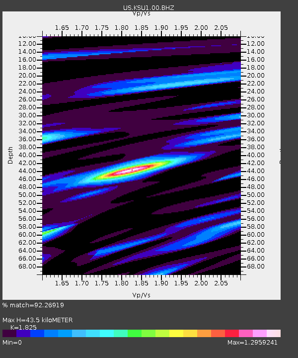
| Estimated Moho Depth: |
43.5 km |
| Estimated Crust Vp/Vs: |
1.83 |
| Assumed Crust Vp: |
6.483 km/s |
| Estimated Crust Vs: |
3.552 km/s |
| Estimated Crust Poisson's Ratio: |
0.29 |
|
| Radial Match: |
92.26919 % |
| Radial Bump: |
400 |
| Transverse Match: |
82.53895 % |
| Transverse Bump: |
400 |
| SOD ConfigId: |
1427151 |
| Insert Time: |
2016-02-13 04:18:29.282 +0000 |
| GWidth: |
2.5 |
| Max Bumps: |
400 |
| Tol: |
0.001 |
|

Signal To Noise
| Channel | StoN | STA | LTA |
| US:KSU1:00:BHZ:20160130T03:35:15.748979Z | 19.316027 | 9.163079E-6 | 4.7437698E-7 |
| US:KSU1:00:BH1:20160130T03:35:15.748979Z | 4.3509398 | 1.49124E-6 | 3.4273972E-7 |
| US:KSU1:00:BH2:20160130T03:35:15.748979Z | 6.8243313 | 3.8185317E-6 | 5.5954666E-7 |
| Arrivals |
| Ps | 5.8 SECOND |
| PpPs | 18 SECOND |
| PsPs/PpSs | 24 SECOND |


