You are here: Home > Network List > TA - USArray Transportable Network (new EarthScope stations) Stations List
> Station A36M Sachs Harbour, NT, CAN > Earthquake Result Viewer
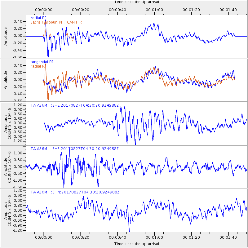
A36M Sachs Harbour, NT, CAN - Earthquake Result Viewer
*The percent match for this event was below the threshold and hence no stack was calculated.
| Earthquake location: |
Admiralty Islands Region, P.N.G. |
| Earthquake latitude/longitude: |
-1.4/148.1 |
| Earthquake time(UTC): |
2017/08/27 (239) 04:17:51 GMT |
| Earthquake Depth: |
10 km |
| Earthquake Magnitude: |
6.6 Mi |
| Earthquake Catalog/Contributor: |
NEIC PDE/at |
|
| Network: |
TA USArray Transportable Network (new EarthScope stations) |
| Station: |
A36M Sachs Harbour, NT, CAN |
| Lat/Lon: |
71.99 N/125.25 W |
| Elevation: |
32 m |
|
| Distance: |
90.3 deg |
| Az: |
18.095 deg |
| Baz: |
266.387 deg |
| Ray Param: |
$rayparam |
*The percent match for this event was below the threshold and hence was not used in the summary stack. |
|
| Radial Match: |
66.76356 % |
| Radial Bump: |
400 |
| Transverse Match: |
44.87229 % |
| Transverse Bump: |
400 |
| SOD ConfigId: |
13570011 |
| Insert Time: |
2019-04-28 15:38:57.383 +0000 |
| GWidth: |
2.5 |
| Max Bumps: |
400 |
| Tol: |
0.001 |
|
Signal To Noise
| Channel | StoN | STA | LTA |
| TA:A36M: :BHZ:20170827T04:30:20.924988Z | 2.1689246 | 2.0261737E-7 | 9.341836E-8 |
| TA:A36M: :BHN:20170827T04:30:20.924988Z | 1.6154603 | 2.2320985E-7 | 1.3817105E-7 |
| TA:A36M: :BHE:20170827T04:30:20.924988Z | 0.91241807 | 1.9414328E-7 | 2.1277887E-7 |
| Arrivals |
| Ps | |
| PpPs | |
| PsPs/PpSs | |


