You are here: Home > Network List > TA - USArray Transportable Network (new EarthScope stations) Stations List
> Station D20K Etivluk River, AK, USA > Earthquake Result Viewer
D20K Etivluk River, AK, USA - Earthquake Result Viewer
| Earthquake location: |
Admiralty Islands Region, P.N.G. |
| Earthquake latitude/longitude: |
-1.4/148.1 |
| Earthquake time(UTC): |
2017/08/27 (239) 04:17:51 GMT |
| Earthquake Depth: |
10 km |
| Earthquake Magnitude: |
6.6 Mi |
| Earthquake Catalog/Contributor: |
NEIC PDE/at |
|
| Network: |
TA USArray Transportable Network (new EarthScope stations) |
| Station: |
D20K Etivluk River, AK, USA |
| Lat/Lon: |
68.71 N/156.61 W |
| Elevation: |
577 m |
|
| Distance: |
79.3 deg |
| Az: |
17.785 deg |
| Baz: |
236.746 deg |
| Ray Param: |
0.049040448 |
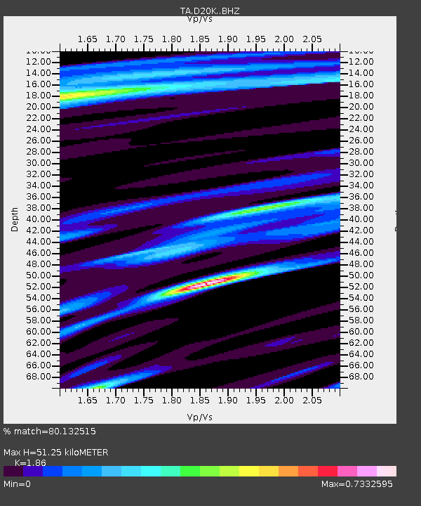
| Estimated Moho Depth: |
51.25 km |
| Estimated Crust Vp/Vs: |
1.86 |
| Assumed Crust Vp: |
6.221 km/s |
| Estimated Crust Vs: |
3.345 km/s |
| Estimated Crust Poisson's Ratio: |
0.30 |
|
| Radial Match: |
80.132515 % |
| Radial Bump: |
400 |
| Transverse Match: |
83.42051 % |
| Transverse Bump: |
400 |
| SOD ConfigId: |
13570011 |
| Insert Time: |
2019-04-28 15:39:03.052 +0000 |
| GWidth: |
2.5 |
| Max Bumps: |
400 |
| Tol: |
0.001 |
|

Signal To Noise
| Channel | StoN | STA | LTA |
| TA:D20K: :BHZ:20170827T04:29:26.000Z | 3.3878877 | 3.281156E-7 | 9.6849604E-8 |
| TA:D20K: :BHN:20170827T04:29:26.000Z | 1.4205977 | 1.2865331E-7 | 9.05628E-8 |
| TA:D20K: :BHE:20170827T04:29:26.000Z | 1.8607694 | 1.4413064E-7 | 7.745755E-8 |
| Arrivals |
| Ps | 7.3 SECOND |
| PpPs | 23 SECOND |
| PsPs/PpSs | 30 SECOND |


