You are here: Home > Network List > TA - USArray Transportable Network (new EarthScope stations) Stations List
> Station D22K Ayikyak River, AK, USA > Earthquake Result Viewer
D22K Ayikyak River, AK, USA - Earthquake Result Viewer
| Earthquake location: |
Admiralty Islands Region, P.N.G. |
| Earthquake latitude/longitude: |
-1.4/148.1 |
| Earthquake time(UTC): |
2017/08/27 (239) 04:17:51 GMT |
| Earthquake Depth: |
10 km |
| Earthquake Magnitude: |
6.6 Mi |
| Earthquake Catalog/Contributor: |
NEIC PDE/at |
|
| Network: |
TA USArray Transportable Network (new EarthScope stations) |
| Station: |
D22K Ayikyak River, AK, USA |
| Lat/Lon: |
68.88 N/152.68 W |
| Elevation: |
532 m |
|
| Distance: |
80.6 deg |
| Az: |
18.396 deg |
| Baz: |
240.515 deg |
| Ray Param: |
0.048145898 |
| Estimated Moho Depth: |
35.0 km |
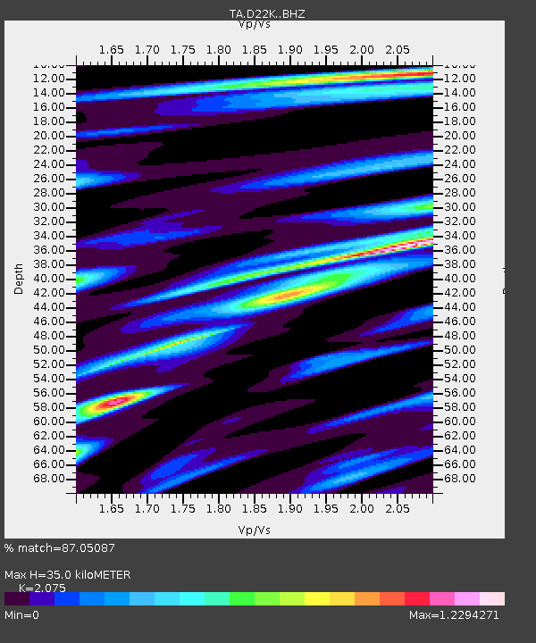
| Estimated Crust Vp/Vs: |
2.08 |
| Assumed Crust Vp: |
6.221 km/s |
| Estimated Crust Vs: |
2.998 km/s |
| Estimated Crust Poisson's Ratio: |
0.35 |
|
| Radial Match: |
87.05087 % |
| Radial Bump: |
400 |
| Transverse Match: |
82.64566 % |
| Transverse Bump: |
400 |
| SOD ConfigId: |
13570011 |
| Insert Time: |
2019-04-28 15:39:04.211 +0000 |
| GWidth: |
2.5 |
| Max Bumps: |
400 |
| Tol: |
0.001 |
|

Signal To Noise
| Channel | StoN | STA | LTA |
| TA:D22K: :BHZ:20170827T04:29:33.025024Z | 6.2388005 | 4.0061212E-7 | 6.4213005E-8 |
| TA:D22K: :BHN:20170827T04:29:33.025024Z | 1.3669546 | 1.513171E-7 | 1.10696504E-7 |
| TA:D22K: :BHE:20170827T04:29:33.025024Z | 1.504035 | 1.8313764E-7 | 1.2176423E-7 |
| Arrivals |
| Ps | 6.2 SECOND |
| PpPs | 17 SECOND |
| PsPs/PpSs | 23 SECOND |


