You are here: Home > Network List > TA - USArray Transportable Network (new EarthScope stations) Stations List
> Station E24K Your Creek, AK, USA > Earthquake Result Viewer
E24K Your Creek, AK, USA - Earthquake Result Viewer
| Earthquake location: |
Admiralty Islands Region, P.N.G. |
| Earthquake latitude/longitude: |
-1.4/148.1 |
| Earthquake time(UTC): |
2017/08/27 (239) 04:17:51 GMT |
| Earthquake Depth: |
10 km |
| Earthquake Magnitude: |
6.6 Mi |
| Earthquake Catalog/Contributor: |
NEIC PDE/at |
|
| Network: |
TA USArray Transportable Network (new EarthScope stations) |
| Station: |
E24K Your Creek, AK, USA |
| Lat/Lon: |
68.07 N/148.49 W |
| Elevation: |
847 m |
|
| Distance: |
81.6 deg |
| Az: |
19.844 deg |
| Baz: |
244.637 deg |
| Ray Param: |
0.047450706 |
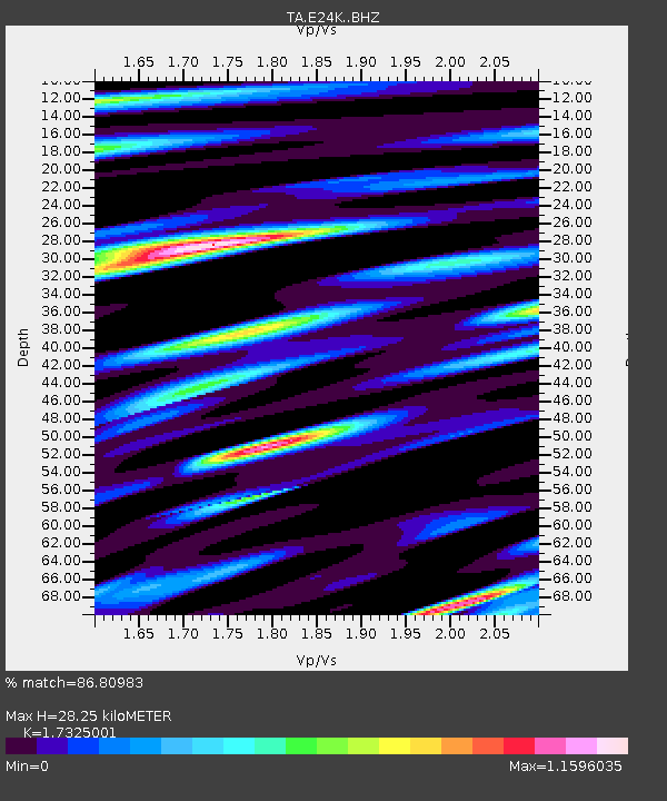
| Estimated Moho Depth: |
28.25 km |
| Estimated Crust Vp/Vs: |
1.73 |
| Assumed Crust Vp: |
6.316 km/s |
| Estimated Crust Vs: |
3.646 km/s |
| Estimated Crust Poisson's Ratio: |
0.25 |
|
| Radial Match: |
86.80983 % |
| Radial Bump: |
400 |
| Transverse Match: |
67.13763 % |
| Transverse Bump: |
400 |
| SOD ConfigId: |
13570011 |
| Insert Time: |
2019-04-28 15:39:13.497 +0000 |
| GWidth: |
2.5 |
| Max Bumps: |
400 |
| Tol: |
0.001 |
|

Signal To Noise
| Channel | StoN | STA | LTA |
| TA:E24K: :BHZ:20170827T04:29:38.349976Z | 2.5342965 | 1.3489488E-7 | 5.3227744E-8 |
| TA:E24K: :BHN:20170827T04:29:38.349976Z | 1.2373494 | 4.311887E-8 | 3.4847773E-8 |
| TA:E24K: :BHE:20170827T04:29:38.349976Z | 1.3455846 | 6.954557E-8 | 5.1684275E-8 |
| Arrivals |
| Ps | 3.4 SECOND |
| PpPs | 12 SECOND |
| PsPs/PpSs | 15 SECOND |


