You are here: Home > Network List > TA - USArray Transportable Network (new EarthScope stations) Stations List
> Station F31M Tsiigehtchic, NWT, CAN > Earthquake Result Viewer
F31M Tsiigehtchic, NWT, CAN - Earthquake Result Viewer
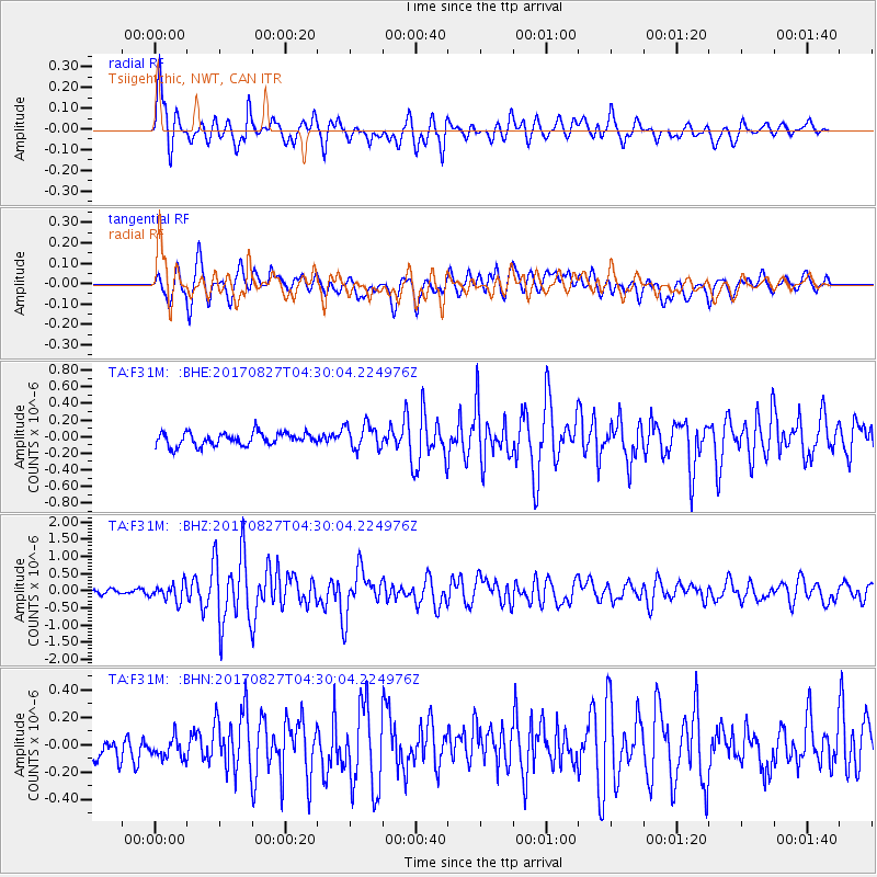
| Earthquake location: |
Admiralty Islands Region, P.N.G. |
| Earthquake latitude/longitude: |
-1.4/148.1 |
| Earthquake time(UTC): |
2017/08/27 (239) 04:17:51 GMT |
| Earthquake Depth: |
10 km |
| Earthquake Magnitude: |
6.6 Mi |
| Earthquake Catalog/Contributor: |
NEIC PDE/at |
|
| Network: |
TA USArray Transportable Network (new EarthScope stations) |
| Station: |
F31M Tsiigehtchic, NWT, CAN |
| Lat/Lon: |
67.44 N/133.74 W |
| Elevation: |
56 m |
|
| Distance: |
86.7 deg |
| Az: |
22.224 deg |
| Baz: |
258.524 deg |
| Ray Param: |
0.043827605 |
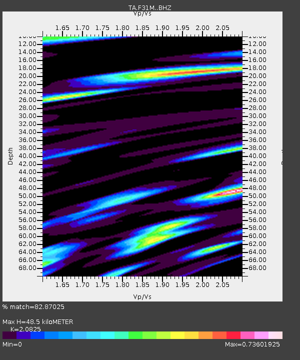
| Estimated Moho Depth: |
48.5 km |
| Estimated Crust Vp/Vs: |
2.08 |
| Assumed Crust Vp: |
6.171 km/s |
| Estimated Crust Vs: |
2.963 km/s |
| Estimated Crust Poisson's Ratio: |
0.35 |
|
| Radial Match: |
82.87025 % |
| Radial Bump: |
400 |
| Transverse Match: |
77.15846 % |
| Transverse Bump: |
400 |
| SOD ConfigId: |
13570011 |
| Insert Time: |
2019-04-28 15:39:25.093 +0000 |
| GWidth: |
2.5 |
| Max Bumps: |
400 |
| Tol: |
0.001 |
|
Signal To Noise
| Channel | StoN | STA | LTA |
| TA:F31M: :BHZ:20170827T04:30:04.224976Z | 3.581983 | 2.4946976E-7 | 6.964571E-8 |
| TA:F31M: :BHN:20170827T04:30:04.224976Z | 0.86680263 | 9.299647E-8 | 1.07286795E-7 |
| TA:F31M: :BHE:20170827T04:30:04.224976Z | 1.9451209 | 1.5234832E-7 | 7.832332E-8 |
| Arrivals |
| Ps | 8.7 SECOND |
| PpPs | 24 SECOND |
| PsPs/PpSs | 32 SECOND |


