You are here: Home > Network List > TA - USArray Transportable Network (new EarthScope stations) Stations List
> Station J25K Salcha River, AK, USA > Earthquake Result Viewer
J25K Salcha River, AK, USA - Earthquake Result Viewer
| Earthquake location: |
Admiralty Islands Region, P.N.G. |
| Earthquake latitude/longitude: |
-1.4/148.1 |
| Earthquake time(UTC): |
2017/08/27 (239) 04:17:51 GMT |
| Earthquake Depth: |
10 km |
| Earthquake Magnitude: |
6.6 Mi |
| Earthquake Catalog/Contributor: |
NEIC PDE/at |
|
| Network: |
TA USArray Transportable Network (new EarthScope stations) |
| Station: |
J25K Salcha River, AK, USA |
| Lat/Lon: |
64.61 N/145.37 W |
| Elevation: |
949 m |
|
| Distance: |
81.4 deg |
| Az: |
23.574 deg |
| Baz: |
248.042 deg |
| Ray Param: |
0.047621537 |
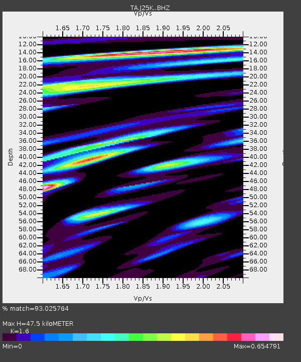
| Estimated Moho Depth: |
47.5 km |
| Estimated Crust Vp/Vs: |
1.60 |
| Assumed Crust Vp: |
6.566 km/s |
| Estimated Crust Vs: |
4.104 km/s |
| Estimated Crust Poisson's Ratio: |
0.18 |
|
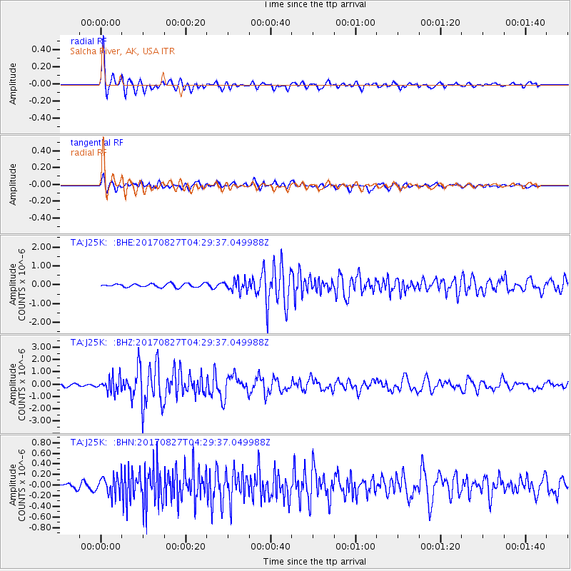
| Radial Match: |
93.025764 % |
| Radial Bump: |
385 |
| Transverse Match: |
80.7042 % |
| Transverse Bump: |
400 |
| SOD ConfigId: |
13570011 |
| Insert Time: |
2019-04-28 15:39:54.704 +0000 |
| GWidth: |
2.5 |
| Max Bumps: |
400 |
| Tol: |
0.001 |
|
Signal To Noise
| Channel | StoN | STA | LTA |
| TA:J25K: :BHZ:20170827T04:29:37.049988Z | 6.091905 | 5.985288E-7 | 9.8249856E-8 |
| TA:J25K: :BHN:20170827T04:29:37.049988Z | 1.930158 | 1.7646104E-7 | 9.1423104E-8 |
| TA:J25K: :BHE:20170827T04:29:37.049988Z | 3.2346377 | 2.8772217E-7 | 8.895036E-8 |
| Arrivals |
| Ps | 4.5 SECOND |
| PpPs | 18 SECOND |
| PsPs/PpSs | 23 SECOND |


