You are here: Home > Network List > TA - USArray Transportable Network (new EarthScope stations) Stations List
> Station K15K Wolf Creek Mountain, AK, USA > Earthquake Result Viewer
K15K Wolf Creek Mountain, AK, USA - Earthquake Result Viewer
| Earthquake location: |
Admiralty Islands Region, P.N.G. |
| Earthquake latitude/longitude: |
-1.4/148.1 |
| Earthquake time(UTC): |
2017/08/27 (239) 04:17:51 GMT |
| Earthquake Depth: |
10 km |
| Earthquake Magnitude: |
6.6 Mi |
| Earthquake Catalog/Contributor: |
NEIC PDE/at |
|
| Network: |
TA USArray Transportable Network (new EarthScope stations) |
| Station: |
K15K Wolf Creek Mountain, AK, USA |
| Lat/Lon: |
62.29 N/161.53 W |
| Elevation: |
346 m |
|
| Distance: |
73.9 deg |
| Az: |
21.998 deg |
| Baz: |
233.245 deg |
| Ray Param: |
0.052665584 |
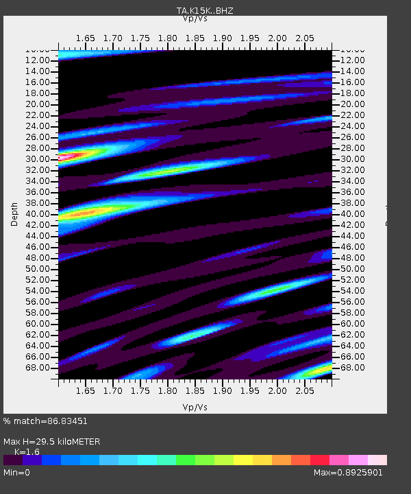
| Estimated Moho Depth: |
29.5 km |
| Estimated Crust Vp/Vs: |
1.60 |
| Assumed Crust Vp: |
6.276 km/s |
| Estimated Crust Vs: |
3.922 km/s |
| Estimated Crust Poisson's Ratio: |
0.18 |
|
| Radial Match: |
86.83451 % |
| Radial Bump: |
400 |
| Transverse Match: |
81.61876 % |
| Transverse Bump: |
400 |
| SOD ConfigId: |
13570011 |
| Insert Time: |
2019-04-28 15:39:56.483 +0000 |
| GWidth: |
2.5 |
| Max Bumps: |
400 |
| Tol: |
0.001 |
|

Signal To Noise
| Channel | StoN | STA | LTA |
| TA:K15K: :BHZ:20170827T04:28:55.700012Z | 2.0033154 | 2.6583479E-7 | 1.3269741E-7 |
| TA:K15K: :BHN:20170827T04:28:55.700012Z | 0.78562504 | 1.0676908E-7 | 1.3590335E-7 |
| TA:K15K: :BHE:20170827T04:28:55.700012Z | 1.1345263 | 1.5205494E-7 | 1.3402504E-7 |
| Arrivals |
| Ps | 2.9 SECOND |
| PpPs | 12 SECOND |
| PsPs/PpSs | 15 SECOND |


