You are here: Home > Network List > TA - USArray Transportable Network (new EarthScope stations) Stations List
> Station 124A Stringfield Ranch, Weed, NM, USA > Earthquake Result Viewer
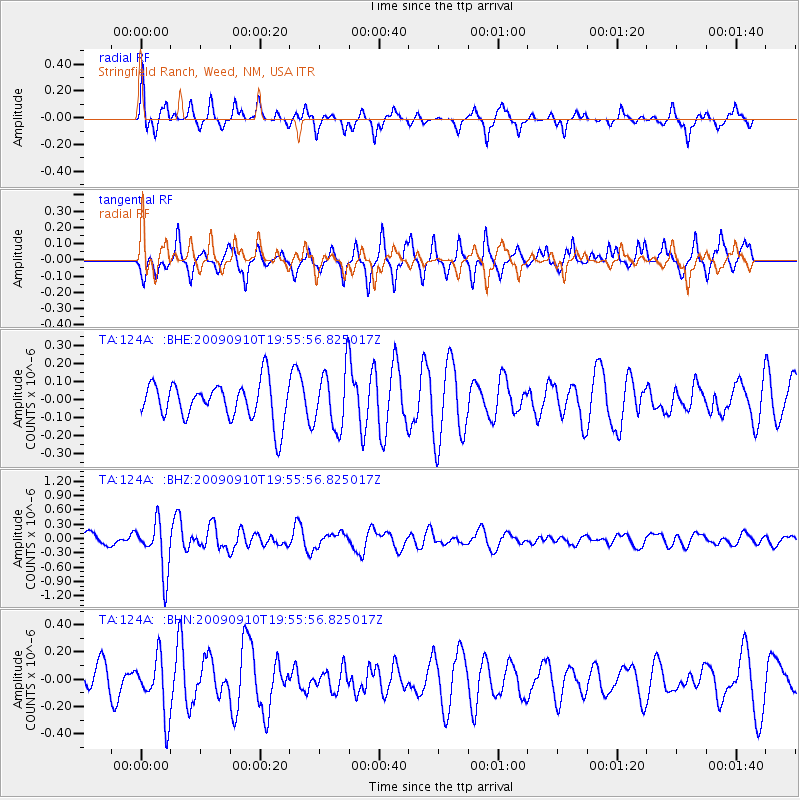
124A Stringfield Ranch, Weed, NM, USA - Earthquake Result Viewer
*The percent match for this event was below the threshold and hence no stack was calculated.
| Earthquake location: |
Easter Island Region |
| Earthquake latitude/longitude: |
-29.9/-111.8 |
| Earthquake time(UTC): |
2009/09/10 (253) 19:46:03 GMT |
| Earthquake Depth: |
10 km |
| Earthquake Magnitude: |
5.5 MW, 5.4 MB |
| Earthquake Catalog/Contributor: |
WHDF/NEIC |
|
| Network: |
TA USArray Transportable Network (new EarthScope stations) |
| Station: |
124A Stringfield Ranch, Weed, NM, USA |
| Lat/Lon: |
32.70 N/105.45 W |
| Elevation: |
2078 m |
|
| Distance: |
62.6 deg |
| Az: |
6.049 deg |
| Baz: |
186.229 deg |
| Ray Param: |
$rayparam |
*The percent match for this event was below the threshold and hence was not used in the summary stack. |
|
| Radial Match: |
75.27797 % |
| Radial Bump: |
269 |
| Transverse Match: |
69.3693 % |
| Transverse Bump: |
370 |
| SOD ConfigId: |
2622 |
| Insert Time: |
2010-03-06 03:04:58.428 +0000 |
| GWidth: |
2.5 |
| Max Bumps: |
400 |
| Tol: |
0.001 |
|
Signal To Noise
| Channel | StoN | STA | LTA |
| TA:124A: :BHZ:20090910T19:55:56.825017Z | 5.1395345 | 5.3310976E-7 | 1.0372724E-7 |
| TA:124A: :BHN:20090910T19:55:56.825017Z | 2.1071804 | 2.102448E-7 | 9.977543E-8 |
| TA:124A: :BHE:20090910T19:55:56.825017Z | 1.5615001 | 1.6485318E-7 | 1.0557359E-7 |
| Arrivals |
| Ps | |
| PpPs | |
| PsPs/PpSs | |


