You are here: Home > Network List > TA - USArray Transportable Network (new EarthScope stations) Stations List
> Station 124A Stringfield Ranch, Weed, NM, USA > Earthquake Result Viewer
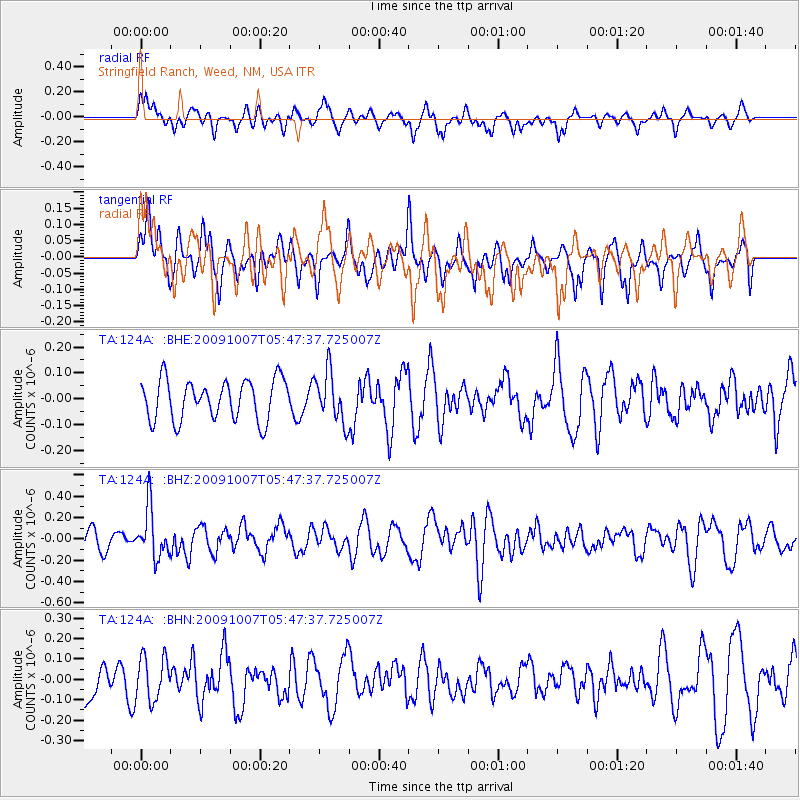
124A Stringfield Ranch, Weed, NM, USA - Earthquake Result Viewer
*The percent match for this event was below the threshold and hence no stack was calculated.
| Earthquake location: |
Rat Islands, Aleutian Islands |
| Earthquake latitude/longitude: |
52.2/178.1 |
| Earthquake time(UTC): |
2009/10/07 (280) 05:38:37 GMT |
| Earthquake Depth: |
138 km |
| Earthquake Magnitude: |
5.6 MB, 5.6 MW, 5.6 MW |
| Earthquake Catalog/Contributor: |
WHDF/NEIC |
|
| Network: |
TA USArray Transportable Network (new EarthScope stations) |
| Station: |
124A Stringfield Ranch, Weed, NM, USA |
| Lat/Lon: |
32.70 N/105.45 W |
| Elevation: |
2078 m |
|
| Distance: |
57.0 deg |
| Az: |
77.875 deg |
| Baz: |
314.408 deg |
| Ray Param: |
$rayparam |
*The percent match for this event was below the threshold and hence was not used in the summary stack. |
|
| Radial Match: |
69.64437 % |
| Radial Bump: |
400 |
| Transverse Match: |
49.786903 % |
| Transverse Bump: |
380 |
| SOD ConfigId: |
2622 |
| Insert Time: |
2010-03-06 03:05:03.583 +0000 |
| GWidth: |
2.5 |
| Max Bumps: |
400 |
| Tol: |
0.001 |
|
Signal To Noise
| Channel | StoN | STA | LTA |
| TA:124A: :BHZ:20091007T05:47:37.725007Z | 3.4824193 | 2.3133833E-7 | 6.643035E-8 |
| TA:124A: :BHN:20091007T05:47:37.725007Z | 1.5498075 | 1.0564818E-7 | 6.816858E-8 |
| TA:124A: :BHE:20091007T05:47:37.725007Z | 1.2543467 | 9.723805E-8 | 7.752087E-8 |
| Arrivals |
| Ps | |
| PpPs | |
| PsPs/PpSs | |


