You are here: Home > Network List > US - United States National Seismic Network Stations List
> Station TPNV Topopah Spring, Nevada, USA > Earthquake Result Viewer
TPNV Topopah Spring, Nevada, USA - Earthquake Result Viewer

| Earthquake location: |
Kamchatka Peninsula, Russia |
| Earthquake latitude/longitude: |
54.0/158.5 |
| Earthquake time(UTC): |
2016/01/30 (030) 03:25:10 GMT |
| Earthquake Depth: |
161 km |
| Earthquake Magnitude: |
7.2 MWW, 7.0 MI, 7.2 MWB |
| Earthquake Catalog/Contributor: |
NEIC PDE/NEIC COMCAT |
|
| Network: |
US United States National Seismic Network |
| Station: |
TPNV Topopah Spring, Nevada, USA |
| Lat/Lon: |
36.95 N/116.25 W |
| Elevation: |
1600 m |
|
| Distance: |
58.5 deg |
| Az: |
69.425 deg |
| Baz: |
316.384 deg |
| Ray Param: |
0.062286966 |
| Estimated Moho Depth: |
54.5 km |
| Estimated Crust Vp/Vs: |
1.61 |
| Assumed Crust Vp: |
6.279 km/s |
| Estimated Crust Vs: |
3.9 km/s |
| Estimated Crust Poisson's Ratio: |
0.19 |
|
| Radial Match: |
91.447525 % |
| Radial Bump: |
400 |
| Transverse Match: |
85.02521 % |
| Transverse Bump: |
400 |
| SOD ConfigId: |
1427151 |
| Insert Time: |
2016-02-13 04:19:36.198 +0000 |
| GWidth: |
2.5 |
| Max Bumps: |
400 |
| Tol: |
0.001 |
|
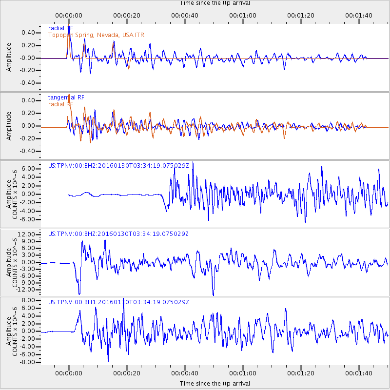
Signal To Noise
| Channel | StoN | STA | LTA |
| US:TPNV:00:BHZ:20160130T03:34:19.075029Z | 31.876154 | 5.8584073E-6 | 1.8378651E-7 |
| US:TPNV:00:BH1:20160130T03:34:19.075029Z | 11.689921 | 2.041443E-6 | 1.7463273E-7 |
| US:TPNV:00:BH2:20160130T03:34:19.075029Z | 6.989049 | 1.6365442E-6 | 2.3415836E-7 |
| Arrivals |
| Ps | 5.6 SECOND |
| PpPs | 22 SECOND |
| PsPs/PpSs | 27 SECOND |


