You are here: Home > Network List > TA - USArray Transportable Network (new EarthScope stations) Stations List
> Station Q17K Contact Creek, Katmai, AK, USA > Earthquake Result Viewer
Q17K Contact Creek, Katmai, AK, USA - Earthquake Result Viewer
| Earthquake location: |
Admiralty Islands Region, P.N.G. |
| Earthquake latitude/longitude: |
-1.4/148.1 |
| Earthquake time(UTC): |
2017/08/27 (239) 04:17:51 GMT |
| Earthquake Depth: |
10 km |
| Earthquake Magnitude: |
6.6 Mi |
| Earthquake Catalog/Contributor: |
NEIC PDE/at |
|
| Network: |
TA USArray Transportable Network (new EarthScope stations) |
| Station: |
Q17K Contact Creek, Katmai, AK, USA |
| Lat/Lon: |
58.26 N/155.89 W |
| Elevation: |
1165 m |
|
| Distance: |
74.1 deg |
| Az: |
27.118 deg |
| Baz: |
239.554 deg |
| Ray Param: |
0.052593604 |
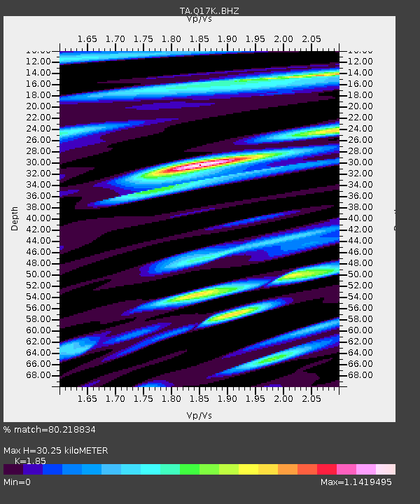
| Estimated Moho Depth: |
30.25 km |
| Estimated Crust Vp/Vs: |
1.85 |
| Assumed Crust Vp: |
6.438 km/s |
| Estimated Crust Vs: |
3.48 km/s |
| Estimated Crust Poisson's Ratio: |
0.29 |
|
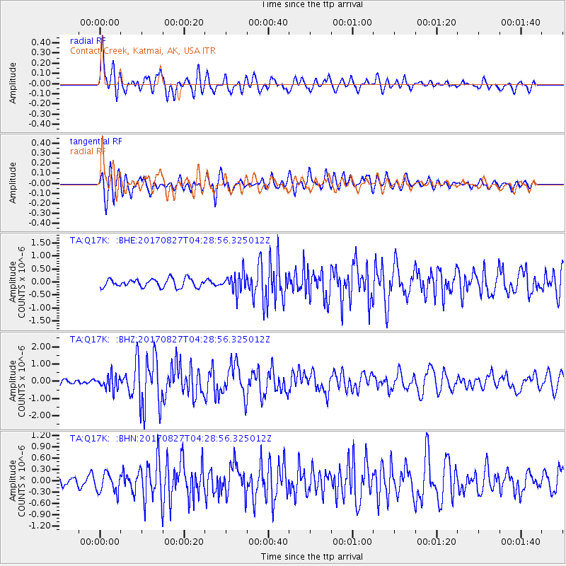
| Radial Match: |
80.218834 % |
| Radial Bump: |
400 |
| Transverse Match: |
75.94805 % |
| Transverse Bump: |
400 |
| SOD ConfigId: |
13570011 |
| Insert Time: |
2019-04-28 15:40:23.514 +0000 |
| GWidth: |
2.5 |
| Max Bumps: |
400 |
| Tol: |
0.001 |
|
Signal To Noise
| Channel | StoN | STA | LTA |
| TA:Q17K: :BHZ:20170827T04:28:56.325012Z | 1.9091637 | 4.0654484E-7 | 2.1294395E-7 |
| TA:Q17K: :BHN:20170827T04:28:56.325012Z | 0.8537788 | 2.5898416E-7 | 3.033387E-7 |
| TA:Q17K: :BHE:20170827T04:28:56.325012Z | 2.2311723 | 3.6038494E-7 | 1.6152269E-7 |
| Arrivals |
| Ps | 4.1 SECOND |
| PpPs | 13 SECOND |
| PsPs/PpSs | 17 SECOND |


