You are here: Home > Network List > TA - USArray Transportable Network (new EarthScope stations) Stations List
> Station Q18K Katmai Hardscrabble Creek, AK, USA > Earthquake Result Viewer
Q18K Katmai Hardscrabble Creek, AK, USA - Earthquake Result Viewer
| Earthquake location: |
Admiralty Islands Region, P.N.G. |
| Earthquake latitude/longitude: |
-1.4/148.1 |
| Earthquake time(UTC): |
2017/08/27 (239) 04:17:51 GMT |
| Earthquake Depth: |
10 km |
| Earthquake Magnitude: |
6.6 Mi |
| Earthquake Catalog/Contributor: |
NEIC PDE/at |
|
| Network: |
TA USArray Transportable Network (new EarthScope stations) |
| Station: |
Q18K Katmai Hardscrabble Creek, AK, USA |
| Lat/Lon: |
58.65 N/155.01 W |
| Elevation: |
1250 m |
|
| Distance: |
74.6 deg |
| Az: |
27.011 deg |
| Baz: |
240.272 deg |
| Ray Param: |
0.05219508 |
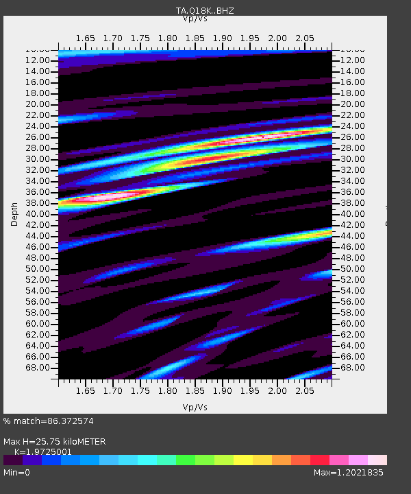
| Estimated Moho Depth: |
25.75 km |
| Estimated Crust Vp/Vs: |
1.97 |
| Assumed Crust Vp: |
6.438 km/s |
| Estimated Crust Vs: |
3.264 km/s |
| Estimated Crust Poisson's Ratio: |
0.33 |
|
| Radial Match: |
86.372574 % |
| Radial Bump: |
400 |
| Transverse Match: |
85.11769 % |
| Transverse Bump: |
400 |
| SOD ConfigId: |
13570011 |
| Insert Time: |
2019-04-28 15:40:23.698 +0000 |
| GWidth: |
2.5 |
| Max Bumps: |
400 |
| Tol: |
0.001 |
|

Signal To Noise
| Channel | StoN | STA | LTA |
| TA:Q18K: :BHZ:20170827T04:28:59.750Z | 2.1047862 | 4.942921E-7 | 2.3484199E-7 |
| TA:Q18K: :BHN:20170827T04:28:59.750Z | 1.3233396 | 2.720497E-7 | 2.0557815E-7 |
| TA:Q18K: :BHE:20170827T04:28:59.750Z | 2.2954826 | 3.424739E-7 | 1.4919472E-7 |
| Arrivals |
| Ps | 4.0 SECOND |
| PpPs | 12 SECOND |
| PsPs/PpSs | 16 SECOND |


