You are here: Home > Network List > TJ - Tajikistan National Seismic Network Stations List
> Station GARM Garm, Tajikistan > Earthquake Result Viewer
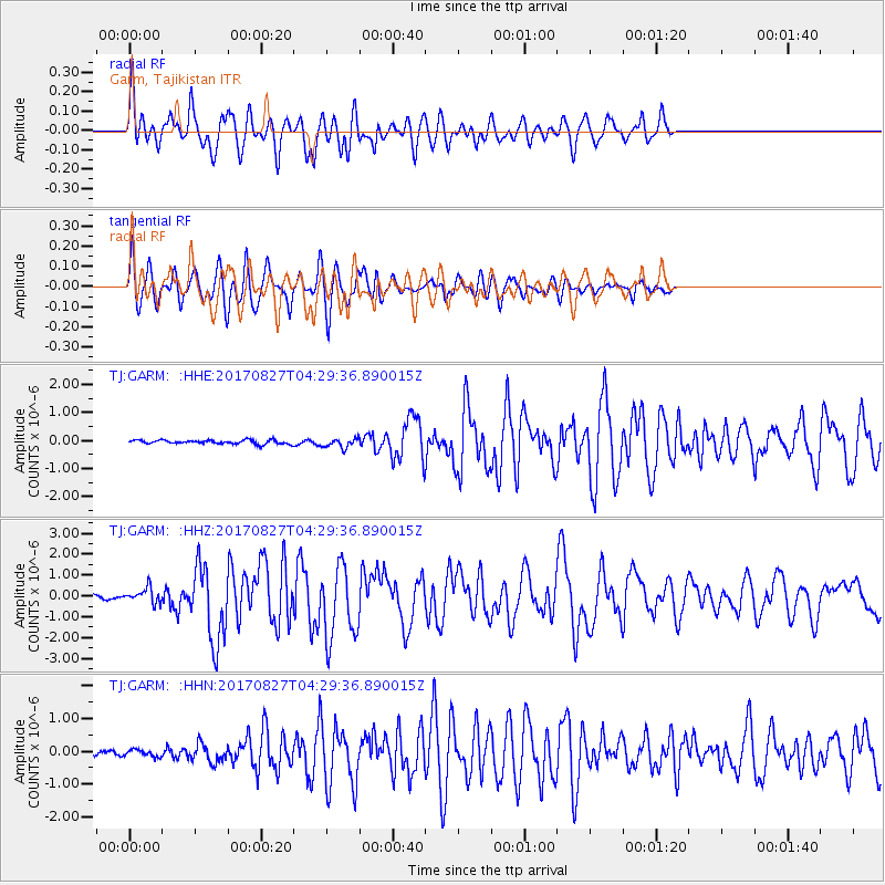
GARM Garm, Tajikistan - Earthquake Result Viewer
*The percent match for this event was below the threshold and hence no stack was calculated.
| Earthquake location: |
Admiralty Islands Region, P.N.G. |
| Earthquake latitude/longitude: |
-1.4/148.1 |
| Earthquake time(UTC): |
2017/08/27 (239) 04:17:51 GMT |
| Earthquake Depth: |
10 km |
| Earthquake Magnitude: |
6.6 Mi |
| Earthquake Catalog/Contributor: |
NEIC PDE/at |
|
| Network: |
TJ Tajikistan National Seismic Network |
| Station: |
GARM Garm, Tajikistan |
| Lat/Lon: |
39.00 N/70.32 E |
| Elevation: |
1305 m |
|
| Distance: |
81.4 deg |
| Az: |
309.625 deg |
| Baz: |
98.813 deg |
| Ray Param: |
$rayparam |
*The percent match for this event was below the threshold and hence was not used in the summary stack. |
|
| Radial Match: |
76.03291 % |
| Radial Bump: |
400 |
| Transverse Match: |
81.4374 % |
| Transverse Bump: |
400 |
| SOD ConfigId: |
13570011 |
| Insert Time: |
2019-04-28 15:40:30.139 +0000 |
| GWidth: |
2.5 |
| Max Bumps: |
400 |
| Tol: |
0.001 |
|
Signal To Noise
| Channel | StoN | STA | LTA |
| TJ:GARM: :HHZ:20170827T04:29:36.890015Z | 3.8613133 | 3.5926723E-7 | 9.304276E-8 |
| TJ:GARM: :HHN:20170827T04:29:36.890015Z | 1.303966 | 1.0363189E-7 | 7.9474376E-8 |
| TJ:GARM: :HHE:20170827T04:29:36.890015Z | 2.4625359 | 1.6444801E-7 | 6.677995E-8 |
| Arrivals |
| Ps | |
| PpPs | |
| PsPs/PpSs | |


