You are here: Home > Network List > AV - Alaska Volcano Observatory Stations List
> Station SPCR Ckakachatna River, Mount Spurr, Alaska > Earthquake Result Viewer
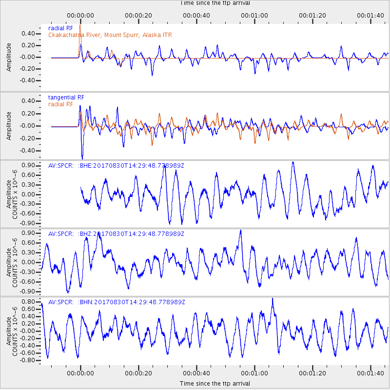
SPCR Ckakachatna River, Mount Spurr, Alaska - Earthquake Result Viewer
*The percent match for this event was below the threshold and hence no stack was calculated.
| Earthquake location: |
Azores Islands Region |
| Earthquake latitude/longitude: |
40.0/-29.4 |
| Earthquake time(UTC): |
2017/08/30 (242) 14:19:14 GMT |
| Earthquake Depth: |
10 km |
| Earthquake Magnitude: |
5.6 Mww |
| Earthquake Catalog/Contributor: |
NEIC PDE/us |
|
| Network: |
AV Alaska Volcano Observatory |
| Station: |
SPCR Ckakachatna River, Mount Spurr, Alaska |
| Lat/Lon: |
61.20 N/152.21 W |
| Elevation: |
984 m |
|
| Distance: |
69.0 deg |
| Az: |
334.143 deg |
| Baz: |
43.767 deg |
| Ray Param: |
$rayparam |
*The percent match for this event was below the threshold and hence was not used in the summary stack. |
|
| Radial Match: |
51.837055 % |
| Radial Bump: |
400 |
| Transverse Match: |
71.653 % |
| Transverse Bump: |
400 |
| SOD ConfigId: |
13570011 |
| Insert Time: |
2019-04-28 15:42:26.194 +0000 |
| GWidth: |
2.5 |
| Max Bumps: |
400 |
| Tol: |
0.001 |
|
Signal To Noise
| Channel | StoN | STA | LTA |
| AV:SPCR: :BHZ:20170830T14:29:48.778989Z | 1.8337905 | 4.862152E-7 | 2.6514215E-7 |
| AV:SPCR: :BHN:20170830T14:29:48.778989Z | 0.76703906 | 2.8025968E-7 | 3.653786E-7 |
| AV:SPCR: :BHE:20170830T14:29:48.778989Z | 2.4986508 | 5.8404856E-7 | 2.3374558E-7 |
| Arrivals |
| Ps | |
| PpPs | |
| PsPs/PpSs | |


