You are here: Home > Network List > UU - University of Utah Regional Network Stations List
> Station CCUT Cedar City, UT, USA > Earthquake Result Viewer
CCUT Cedar City, UT, USA - Earthquake Result Viewer
| Earthquake location: |
Kamchatka Peninsula, Russia |
| Earthquake latitude/longitude: |
54.0/158.5 |
| Earthquake time(UTC): |
2016/01/30 (030) 03:25:10 GMT |
| Earthquake Depth: |
161 km |
| Earthquake Magnitude: |
7.2 MWW, 7.0 MI, 7.2 MWB |
| Earthquake Catalog/Contributor: |
NEIC PDE/NEIC COMCAT |
|
| Network: |
UU University of Utah Regional Network |
| Station: |
CCUT Cedar City, UT, USA |
| Lat/Lon: |
37.55 N/113.36 W |
| Elevation: |
2127 m |
|
| Distance: |
59.7 deg |
| Az: |
66.993 deg |
| Baz: |
316.874 deg |
| Ray Param: |
0.061542857 |
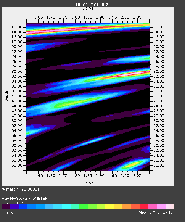
| Estimated Moho Depth: |
30.75 km |
| Estimated Crust Vp/Vs: |
2.02 |
| Assumed Crust Vp: |
6.194 km/s |
| Estimated Crust Vs: |
3.063 km/s |
| Estimated Crust Poisson's Ratio: |
0.34 |
|
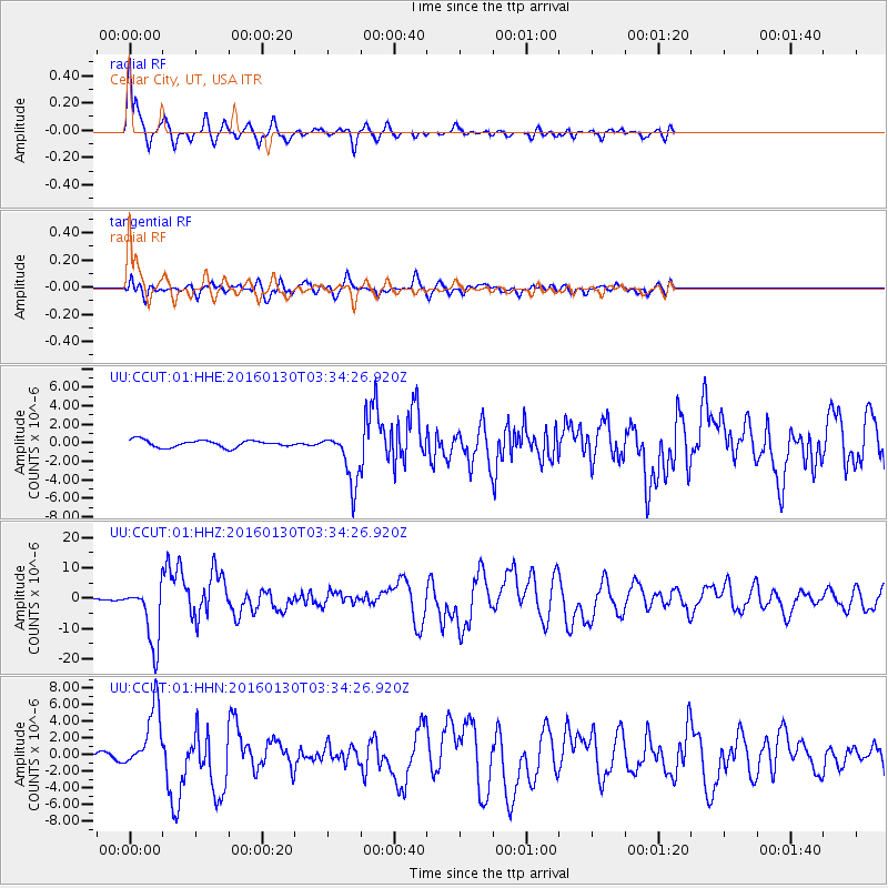
| Radial Match: |
90.88881 % |
| Radial Bump: |
400 |
| Transverse Match: |
75.11649 % |
| Transverse Bump: |
400 |
| SOD ConfigId: |
1427151 |
| Insert Time: |
2016-02-13 04:20:45.412 +0000 |
| GWidth: |
2.5 |
| Max Bumps: |
400 |
| Tol: |
0.001 |
|
Signal To Noise
| Channel | StoN | STA | LTA |
| UU:CCUT:01:HHZ:20160130T03:34:26.920Z | 25.942162 | 9.9772415E-6 | 3.8459564E-7 |
| UU:CCUT:01:HHN:20160130T03:34:26.920Z | 18.94561 | 3.7796738E-6 | 1.9950129E-7 |
| UU:CCUT:01:HHE:20160130T03:34:26.920Z | 7.580864 | 2.8782579E-6 | 3.7967413E-7 |
| Arrivals |
| Ps | 5.3 SECOND |
| PpPs | 14 SECOND |
| PsPs/PpSs | 20 SECOND |


