You are here: Home > Network List > TA - USArray Transportable Network (new EarthScope stations) Stations List
> Station E20K Nigu River, AK, USA > Earthquake Result Viewer
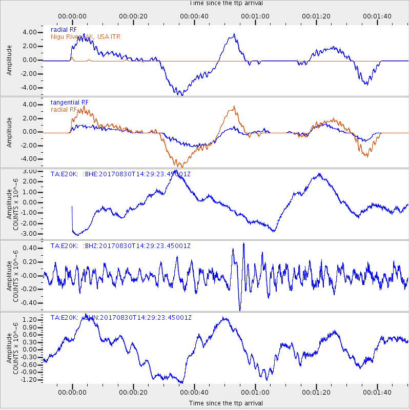
E20K Nigu River, AK, USA - Earthquake Result Viewer
*The percent match for this event was below the threshold and hence no stack was calculated.
| Earthquake location: |
Azores Islands Region |
| Earthquake latitude/longitude: |
40.0/-29.4 |
| Earthquake time(UTC): |
2017/08/30 (242) 14:19:14 GMT |
| Earthquake Depth: |
10 km |
| Earthquake Magnitude: |
5.6 Mww |
| Earthquake Catalog/Contributor: |
NEIC PDE/us |
|
| Network: |
TA USArray Transportable Network (new EarthScope stations) |
| Station: |
E20K Nigu River, AK, USA |
| Lat/Lon: |
68.26 N/156.19 W |
| Elevation: |
866 m |
|
| Distance: |
65.0 deg |
| Az: |
340.77 deg |
| Baz: |
42.761 deg |
| Ray Param: |
$rayparam |
*The percent match for this event was below the threshold and hence was not used in the summary stack. |
|
| Radial Match: |
26.837309 % |
| Radial Bump: |
400 |
| Transverse Match: |
28.086262 % |
| Transverse Bump: |
400 |
| SOD ConfigId: |
13570011 |
| Insert Time: |
2019-04-28 15:48:02.716 +0000 |
| GWidth: |
2.5 |
| Max Bumps: |
400 |
| Tol: |
0.001 |
|
Signal To Noise
| Channel | StoN | STA | LTA |
| TA:E20K: :BHZ:20170830T14:29:23.45001Z | 1.1572192 | 1.0020858E-7 | 8.65943E-8 |
| TA:E20K: :BHN:20170830T14:29:23.45001Z | 4.4009514 | 1.5362106E-6 | 3.4906327E-7 |
| TA:E20K: :BHE:20170830T14:29:23.45001Z | 3.36938 | 3.2985376E-6 | 9.789746E-7 |
| Arrivals |
| Ps | |
| PpPs | |
| PsPs/PpSs | |


