You are here: Home > Network List > TA - USArray Transportable Network (new EarthScope stations) Stations List
> Station 124A Stringfield Ranch, Weed, NM, USA > Earthquake Result Viewer
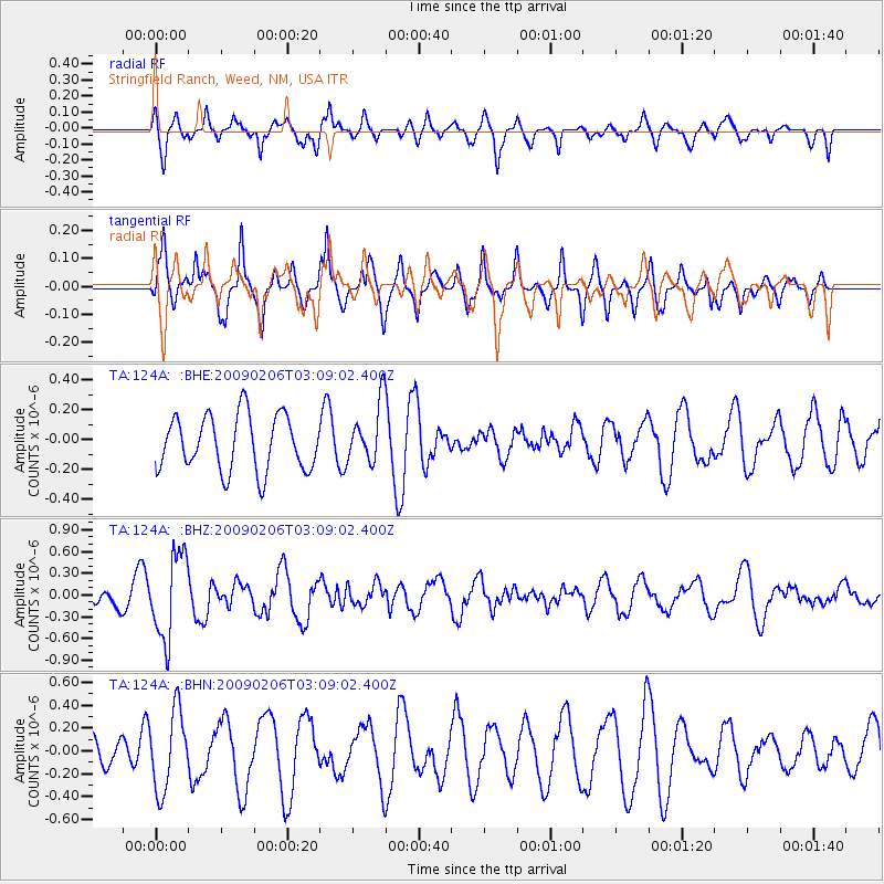
124A Stringfield Ranch, Weed, NM, USA - Earthquake Result Viewer
*The percent match for this event was below the threshold and hence no stack was calculated.
| Earthquake location: |
Near Coast Of Northern Chile |
| Earthquake latitude/longitude: |
-28.0/-71.1 |
| Earthquake time(UTC): |
2009/02/06 (037) 02:58:35 GMT |
| Earthquake Depth: |
52 km |
| Earthquake Magnitude: |
5.5 MB |
| Earthquake Catalog/Contributor: |
WHDF/NEIC |
|
| Network: |
TA USArray Transportable Network (new EarthScope stations) |
| Station: |
124A Stringfield Ranch, Weed, NM, USA |
| Lat/Lon: |
32.70 N/105.45 W |
| Elevation: |
2078 m |
|
| Distance: |
68.6 deg |
| Az: |
329.275 deg |
| Baz: |
147.596 deg |
| Ray Param: |
$rayparam |
*The percent match for this event was below the threshold and hence was not used in the summary stack. |
|
| Radial Match: |
45.021717 % |
| Radial Bump: |
346 |
| Transverse Match: |
62.798267 % |
| Transverse Bump: |
324 |
| SOD ConfigId: |
2658 |
| Insert Time: |
2010-03-06 03:05:47.747 +0000 |
| GWidth: |
2.5 |
| Max Bumps: |
400 |
| Tol: |
0.001 |
|
Signal To Noise
| Channel | StoN | STA | LTA |
| TA:124A: :BHZ:20090206T03:09:02.400Z | 2.3948662 | 5.8195377E-7 | 2.4300053E-7 |
| TA:124A: :BHN:20090206T03:09:02.400Z | 1.7740998 | 3.467734E-7 | 1.9546442E-7 |
| TA:124A: :BHE:20090206T03:09:02.400Z | 1.0872643 | 2.0023087E-7 | 1.8416026E-7 |
| Arrivals |
| Ps | |
| PpPs | |
| PsPs/PpSs | |


