You are here: Home > Network List > TA - USArray Transportable Network (new EarthScope stations) Stations List
> Station 124A Stringfield Ranch, Weed, NM, USA > Earthquake Result Viewer
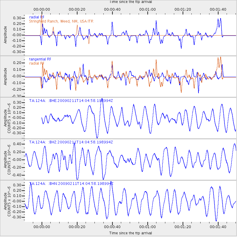
124A Stringfield Ranch, Weed, NM, USA - Earthquake Result Viewer
*The percent match for this event was below the threshold and hence no stack was calculated.
| Earthquake location: |
Fiji Islands |
| Earthquake latitude/longitude: |
-16.2/178.3 |
| Earthquake time(UTC): |
2009/02/11 (042) 13:52:41 GMT |
| Earthquake Depth: |
10 km |
| Earthquake Magnitude: |
5.6 MB, 5.3 MS, 5.7 MW, 5.7 MW |
| Earthquake Catalog/Contributor: |
WHDF/NEIC |
|
| Network: |
TA USArray Transportable Network (new EarthScope stations) |
| Station: |
124A Stringfield Ranch, Weed, NM, USA |
| Lat/Lon: |
32.70 N/105.45 W |
| Elevation: |
2078 m |
|
| Distance: |
87.5 deg |
| Az: |
55.05 deg |
| Baz: |
249.054 deg |
| Ray Param: |
$rayparam |
*The percent match for this event was below the threshold and hence was not used in the summary stack. |
|
| Radial Match: |
51.82085 % |
| Radial Bump: |
352 |
| Transverse Match: |
51.825653 % |
| Transverse Bump: |
334 |
| SOD ConfigId: |
2658 |
| Insert Time: |
2010-03-06 03:05:52.432 +0000 |
| GWidth: |
2.5 |
| Max Bumps: |
400 |
| Tol: |
0.001 |
|
Signal To Noise
| Channel | StoN | STA | LTA |
| TA:124A: :BHZ:20090211T14:04:58.198994Z | 1.1157291 | 2.2668665E-7 | 2.0317356E-7 |
| TA:124A: :BHN:20090211T14:04:58.198994Z | 0.9770706 | 1.2137849E-7 | 1.2422694E-7 |
| TA:124A: :BHE:20090211T14:04:58.198994Z | 3.015215 | 2.6140944E-7 | 8.669678E-8 |
| Arrivals |
| Ps | |
| PpPs | |
| PsPs/PpSs | |


