You are here: Home > Network List > TA - USArray Transportable Network (new EarthScope stations) Stations List
> Station Q25A Bedland, Calhan, CO, USA > Earthquake Result Viewer
Q25A Bedland, Calhan, CO, USA - Earthquake Result Viewer
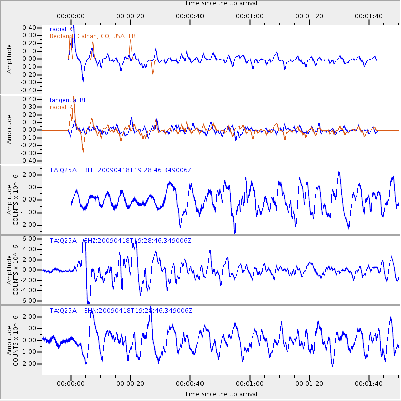
| Earthquake location: |
Kuril Islands |
| Earthquake latitude/longitude: |
46.0/151.4 |
| Earthquake time(UTC): |
2009/04/18 (108) 19:17:58 GMT |
| Earthquake Depth: |
35 km |
| Earthquake Magnitude: |
6.3 MB, 6.3 MS, 6.6 MW, 6.4 MW |
| Earthquake Catalog/Contributor: |
WHDF/NEIC |
|
| Network: |
TA USArray Transportable Network (new EarthScope stations) |
| Station: |
Q25A Bedland, Calhan, CO, USA |
| Lat/Lon: |
38.91 N/104.25 W |
| Elevation: |
2001 m |
|
| Distance: |
71.7 deg |
| Az: |
52.768 deg |
| Baz: |
314.666 deg |
| Ray Param: |
0.054105476 |
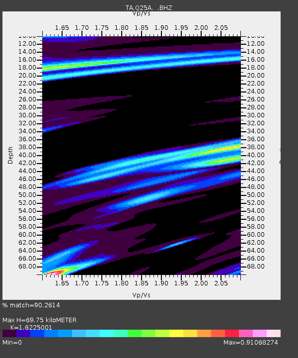
| Estimated Moho Depth: |
69.75 km |
| Estimated Crust Vp/Vs: |
1.62 |
| Assumed Crust Vp: |
6.159 km/s |
| Estimated Crust Vs: |
3.796 km/s |
| Estimated Crust Poisson's Ratio: |
0.19 |
|
| Radial Match: |
90.2614 % |
| Radial Bump: |
335 |
| Transverse Match: |
76.727 % |
| Transverse Bump: |
400 |
| SOD ConfigId: |
2760 |
| Insert Time: |
2010-03-06 03:05:58.815 +0000 |
| GWidth: |
2.5 |
| Max Bumps: |
400 |
| Tol: |
0.001 |
|
Signal To Noise
| Channel | StoN | STA | LTA |
| TA:Q25A: :BHZ:20090418T19:28:46.349006Z | 14.260253 | 2.5506972E-6 | 1.788676E-7 |
| TA:Q25A: :BHN:20090418T19:28:46.349006Z | 2.6494277 | 6.2266935E-7 | 2.3502032E-7 |
| TA:Q25A: :BHE:20090418T19:28:46.349006Z | 2.2966435 | 8.874418E-7 | 3.8640817E-7 |
| Arrivals |
| Ps | 7.3 SECOND |
| PpPs | 29 SECOND |
| PsPs/PpSs | 36 SECOND |


